
8.8: Review and Additional Resources
- Page ID
- 16085

Review
Review and assess your learning. Start with the "Important Terms and Concepts" to ensure you know the terminology related to the topic of the chapter and concepts discussed. Move on to the "Review Questions" to answer critical thinking questions about concepts and processes discussed in the chapter. Finally, test your overall understanding by taking the "Self-assessment quiz".
-
- Air mass
- a vast pool of air having similar temperature and moisture characteristics over its horizontal extent.
-
- Air mass source region
- where air masses are born; where they take on their characteristic temperature and moisture content
-
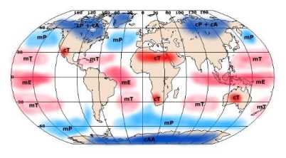
- cP air mass
- Continental polar (cP) air is considered a cold and dry air mass that is warmer than the arctic air mass located to the north. Continental polar air is typically a stable or conditionally stable mass of air.
-
- mP air mass
- Maritime polar (mP) air is cool and moist air that brings mild weather to coastal locations. Maritime polar air is warmer than continental polar air in the winter as the surface temperature of the ocean is higher.
-
- cA air mass
- Continental arctic air (cA) is typically described as extremely cold and dry.
-
- cAA air mass
- an exceedingly cold air mass and is drier than its arctic counterpart as the source region is the continent of Antarctica.
-
- cT air mass
- Found over subtropical and tropical continents the source region for the hot and dry
-
- Air mass modification
- As air masses move out of their source region the temperature and moisture content of air masses are modified.
-
- Front
- boundaries between contrasting masses of air.
-
- Cold front
- where cold air replaces warm air.
-
- Warm front
- where warm air replaces cold air.
-
- Occluded front
- forms when a cold front catches up with a warm front.
-
- Stationary front
- where no change in air masses or movement of the front occurs.
-
- Quasi-stationary front
- found migrating within a particular latitudinal zone throughout most of the year.
-
- Polar front
- the boundary between polar-type air and tropical-type air.
-
- Arctic front
- the boundary between cold arctic air mass and the warmer air of the polar cell.
-
- Warm front weather
-
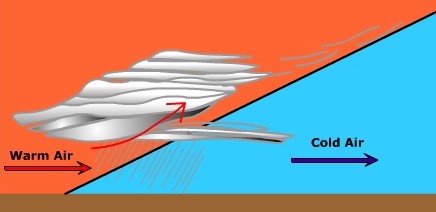
Profile view of warm front
-
- Cold front weather
-
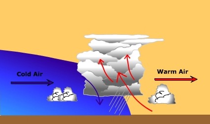
Profile of Cold Front
-
- Warm sector weather
- increase in the humidity of the air; "fair weather" clouds are often created by convection and instability in the warm and humid afternoon air. After a while the winds start to shift to the southwest and the humidity continues to rise.
-
- Cyclogenesis
- the development and intensification of a cyclone
-
- Initial Stage - Cyclogenesis
- opposing streams of air meet and create a cyclone shear
-
- Wave Stage- Cyclogenesis
- Once the air collides and cyclonic circulation commences, warm air from the south invades where cold air was once located north of the polar front. The developing system takes on the characteristic wave form
-
- Occluded Stage- Cyclogenesis
- Being more dense, the air behind the cold front can "bulldoze" the warmer and less dense air out of the way. The warm air rises off the surface and glides up and over the colder more dense air ahead of the warm front. there is less horizontal displacement and the warm front moves slower across the earth than does a cold front. Over time the cold front catches up with the warm front and the cyclone starts to occlude.
-
- Dissolving Stage- Cyclogenesis
- The system enters the dissolving stage after it occludes and the lifting mechanism is cutoff. Without the convergence and uplift, the cyclone dissipates in the atmosphere.
-
- Thunderstorm - Cumulus stage
- The initial stage of development. During this stage warm, moist, and unstable air is lifted from the surface. As the air ascends, it cools and upon reaching its dew point temperature begins to condense into a cumulus cloud. Near the end of this stage precipitation forms.
-
- Thunderstorm - Mature Stage
- The second stage - During the mature stage warm, moist updrafts continue to feed the thunderstorm while cold downdrafts begin to form. The downdrafts are a product of the entrainment of cool, dry air into the cloud by the falling rain. As rain falls through the air it drags the cool, dry air that surrounds the cloud into it. As dry air comes in contact with cloud and rain droplets they evaporate cooling the cloud. The falling rain drags this cool air to the surface as a cold downdraft.
-
- Thunderstorm - Dissipating Stage
- The final stage - the thunderstorm dissolves away. By this point, the entrainment of cool air into the cloud helps stabilize the air. In the case of the air mass thunderstorm, the surface no longer provides enough convective uplift to continue fueling the storm. As a result, the warm updrafts have ceased and only the cool downdrafts are present. The downdrafts end as the rain ceases and soon the thunderstorm dissipates.
-
- Lightning
- a massive discharge of electricity in response to a charge differential.
-
- Thunder
- a shockwave through the atmosphere caused by lightning
-
- Tornado
- an intense system of low pressure with violent updrafts and converging winds.
-
- Hurricane
- a large rotating cyclonic system born in the tropics.
-
- Storm Surge
- the high water level that accompanies a hurricane as it comes ashore.
Describe the characteristics of an air mass source region.
- Answer
-
An air mass source region is one that has flat terrain and dominated by high pressure
Describe two ways in which air masses can be modified.
- Answer
-
Air masses are modified by the surface over which they travel. For example, an mT air mass that passes over a cold ocean current is chilled at the surface enhancing stability. Cold air masses traveling over warm surface are heated enhancing their instability.
Describe the characteristics of a front.
- Answer
-
A front is boundary between contrasting masses of air. They are a zone of converging air and lower pressure.
Compare and contrast mP, cP, mT, cT air masses.
- Answer
-
mP air masses are cool and moist forming over oceans at about 60o N and S.
cP air masses are cold and dry forming over continents at about 60o N.
mT air masses are warm and moist air masses forming over oceans at about 30o N and S.
cT air are warm and dry air masses forming over continents at about 30o N and S.
Describe the process of cyclogenesis.
- Answer
-
Cyclones form along frontal boundaries like the polar front where air is converging from opposite directions. A twisting motion is created as cyclonic shear takes place between the converging air streams. The surface convergence is supported by upper level divergence in the jet stream. The spiraling storm creates a cold front as cold air pushes into regions once occupied by warm air. A warm front is spawned where warm air intrudes into regions once dominated by cold air. Through time the cold front and warm front merge to form an occlusion. Finally the storm dissipates.
Describe the weather changes (e.g. temperature change, pressure tendency, clouds, wind direction) associated with the passage of a warm front.
- Answer
-
A change in cloud cover from cirrus, to cirrostratus, altostratus, and stratus is typical of the approach of a warm front. Air pressure decreases as the front approach, then increases after passage. Nimbostratus clouds are present along the warm front if it is precipitating. Low intensity/long duration precipitation is typical of nimbostratus clouds. Wind are likely to shift from an easterly direction to a southerly direction as the warm from passes. Air temperatures rise upon the passage of the front.

Describe the weather changes (e.g. temperature change, pressure tendency, clouds, wind direction) associated with the passage of a cold front.
- Answer
-
The air ahead of a cold front is generally from the south in the warm sector. Pressure drops as the front approaches. Cumulus clouds grow into cumulonimbus clouds and intense, but short-lasting precipitation occurs. As the front passes, wind shifts from a southerly/southwesterly direction toward the west and possibly northwest. Temperatures decrease as the front passes. After passage, cloud cover dissipates.

Compare and Contrast the kind of precipitation associated with cold and warm fronts.
- Answer
-
Precipitation along warm fronts tends to be low intensity and long in duration. Precipitation along cold fronts tends to be high intensity and short in duration.
Describe the three stages of thunderstorm development.
- Answer
-
Cumulus stage: Creation of a cumulus cloud by updrafts of warm, moist air
Mature stage: Updrafts of warm moist air fuels the developing storm. Downdrafts of cold dry air is created by precipitation entrainment.
Decay stage: Downdrafts predominate as uplift of warm moist air ceases.
Describe the conditions under which tornadoes form.
- Answer
-
There is much we do not know about tornadoes. Tornadoes are most common during the Spring when greatly contrasting air masses collide to produce severe storm systems. Wind shear within the severe thunderstorm causes rotation of air about a horizontal axis. The rotating circulation is tilted into the vertical by the updrafts in the thunderstorm. As the rotating air increases in height and shrinks in size a mesocyclone is formed. For whatever reason, a tornado funnel is spawned within the mesocyclone.
Under what conditions are hurricanes most likely to form?
- Answer
-
A hurricane develops from a tropical disturbance once it reaches sustained winds in excess of 75 mph (65 knots). Most hurricanes form poleward of 10o latitude as the Coriolis effect is too weak closer to the equator. Hurricanes form in a uniform mass of warm air over tropical oceans with temperatures of 80o F (26.5o C) through a depth of 200 feet (60 meters).
What creates the most damage from a hurricane?
- Answer
-
The high water level that precedes the hurricane called the "storm surge" creates the most damage due to flooding.
- At a warm front
- warm air replaces cold air
- a trough of lower pressure is found
- stratus - type clouds are found
- all the above
- Which of the following air masses are colder than the surface over which it is traveling?
- mTw
- mTu
- cPk
- none of the above
- The cold sector of a midlatitude cyclone
- experiences southerly winds
- generates nimbostratus clouds
- experiences light precipitation of long duration
- none of the above
- The mature stage of thunderstorm formation
- experiences mostly updrafts of air
- experiences updrafts and downdrafts
- experiences mostly downdrafts
- none of the above
- Which of the following is not a characteristic of a source region
- a region of little to no windiness
- areas dominated by high pressure
- areas dominated by low pressure
- regions of low relief
- A front
- is a boundary between contrasting masses of air
- is a zone of lower pressure
- is a boundary between opposing centers of high pressure
- can have all the above characteristics
- ______ is fundamentally responsible for the creation of midlatitude cyclones.
- large pressure gradients
- cyclonic shear
- large temperature gradients
- none of the above
- Which of the following is not associated with a cold front
- cumulonimbus clouds
- warm air replacing cold air
- possibility of intense rain of short duration
- all the above are associated with a cold front.
- The wind direction ahead of a warm front is generally
- from the east
- from the south
- from the north
- from the west
- Which of the following is not true about cP air?
- cP air is generally unstable air
- cP air is generally found behind a cold front
- cP air that affects North America has its source in central Canada
- cP air is found in the cold sector of a midlatitude cyclone
- Answer
-
- D
- C
- D
- B
- C
- D
- B
- B
- A
- A
Additional Resources
Focus on The Physical Environment: "Weather Forecasting through the Ages" (NASA Earth Observatory)
Connections: "Trees lost to Katrina May Present Climate Challenge" (NPR) 
Physical Geography Today: US National Weather Service - NOAA | US National Hurricane Center - NOAA
World of Change: Severe Storms (NASA Earth Observatory)
Multimedia
"Super Twisters" (National Geographic)
"Tracking Hurricanes" (PBS) The News Hour with Jim Lehrer Oct. 1, 2003 "For years, scientists have worked to develop powerful new tools to predict the paths of hurricanes and monitor their likely impact. Betty Ann Bowser reports on the latest technologies meteorologists are using to keep tabs on these devastating storms and what new tools are being developed."
"Hunting Killer Storms: Flying into the Eye of Isabel WGBH Forum Network Mish Michaels, meteorologist, WBZ-TV4 talks about her adventures chasing tornadoes, flying into hurricanes and trekking to Mt. Washington during the winter. (54:50)
"Tornado Sound " (NPR) Weekend Edition May 18, 2003 "Host Liane Hansen speaks with physicist Al Bedard, who studies the sounds of tornadoes at the Environmental Technology Laboratory of the National Oceanic and Atmospheric Administration.
"Looking at Hurricanes" (NASA/GSFC) Explore the "latest" technology for observing hurricanes.
["Storm that Drowned a City" from NOVA for an in depth look at Hurricane Katrina's impact on New Orleans, LA.]
Interactivities
- Realtime station model plotting and interpretation (WeatherWise)
Readings
![]() Tornadoes....Nature's Most Violent Storms
Tornadoes....Nature's Most Violent Storms
Visualization
![]() Weather Map Viewer (M. Ritter) - Current weather map slide show.
Weather Map Viewer (M. Ritter) - Current weather map slide show.
![]() "How hurricanes form" (CNN)
"How hurricanes form" (CNN)