
6.11: Review and Additional Resources
- Page ID
- 16037

Review
Assess your learning. Start with the "Important Terms and Concepts" to ensure you know the terminology related to the topic of the chapter and concepts discussed. Move on to the "Review Questions" to answer critical thinking questions about concepts and processes discussed in the chapter. Finally, test your overall understanding by taking the "Self-assessment quiz".
Important Terms and Concepts \(\PageIndex{1}\)
-
- Air pressure
- the force exerted by the weight of a column of air above a particular location
-
- Average sea-level pressure
- serves as the division between what we call "high pressure" and "low pressure" at the surface
-
- High pressure
- values greater than 1013.2 mb
-
- Low pressure
- below 1013.2 mb
-
- Wind
- nothing more than the movement of air molecules from one place to the next
-
- Pressure gradient
- The spacing of isobars indicates the change in pressure over distance
-
- Coriolis effect
- a mass moving in a rotating system experiences a force acting perpendicular to the direction of motion and to the axis of rotation
-
- Friction
- The friction imposed on air mechanically slows the wind and diverts its direction.
-
- Cyclone
- areas of low pressure
-
- Anticyclone
- areas of high pressure that exhibit nearly circular isobars
-
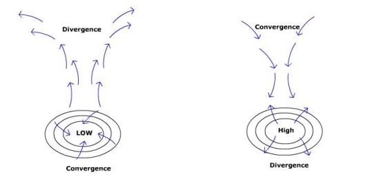
- Convergence
- moving towards a point/area
-
- Divergence
- moving away from a point/area
-
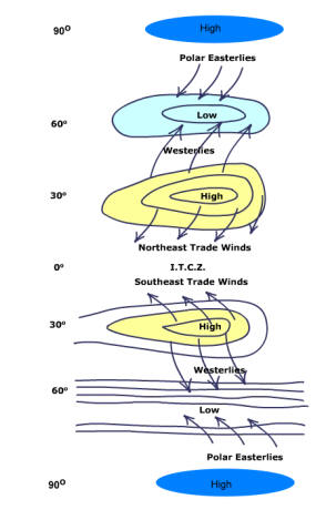
- Intertropical convergence zone
- The Equatorial trough
-
- Subtropical high pressure
- Upper air convergence and radiational cooling cause the air to subside in the subtropics. As the air reaches the surface, atmospheric pressure increases forming the subtropical highs
-
- Subpolar low pressure
- The polar easterlies collide with the westerly wind belt at about 60 N and S creating a broad belt of low pressure
-
- Polar high
- dome of high pressure created by loss of energy at the poles
-
- Northeast tradewinds
- the pressure gradient between the high at 30o N and the low over the equator
-
- Westerlies
- wind belt
-
- Polar easterlies
- Air moving equatorward is turned in an easterly direction
-
- Monsoon
- wind that changes direction with season
-
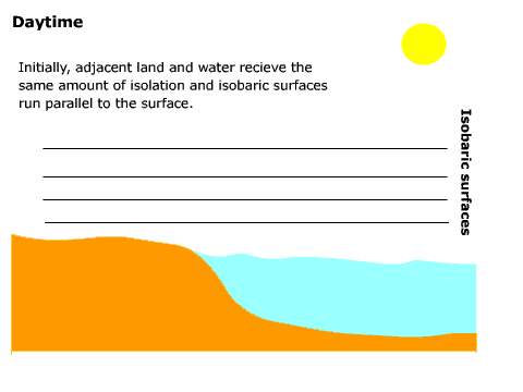
- Land/Sea breeze
- created along coasts where land and water create variations in pressure due to differences in the way these two bodies heat and cool.
-
- Chinook
- a warm dry wind on the leeward side of a mountain
-
- Mountain/Valley wind
- During the daytime, mountain slopes warm causing the air over the slope to be warmer than the air over the valley at the same elevation. Warming the air causes it to rise upwards creating a valley wind. During the evening, the air chills due to a loss of surface energy to space. The cool dense air moves down slope as a mountain wind.
-
- Santa Ana wind
- warm and dry wind.
-
- Upper-level westerlies
- the upper troposphere poleward of 15o to 20o latitude there is an average westerly flow
-
- Upper-level easterlies
- Between 15o - 20o north and south latitude; considered to be an extension of the trade winds
-
- Jet Stream
- a high speed corridor of air responsible for creating and moving large pressure systems through the midlatitudes
-
- Circumpolar vortex
- The subsidence creates a vast area of low pressure aloft
-
- Meridonal flow
- transfer of cold air toward the south and warm air toward the north
-
- Zonal Flow
- edge is flatter, running more west to east in direction
-
- Warm ocean current
- corridors of warm water moving from the tropics poleward where they release energy to the air.
-
- Cold ocean current
- corridors of cold water moving from higher latitudes toward the equator
-
- El Niño
- weakening of the trade winds in the central and western Pacific allows warm water to invade the eastern Pacific. Along the Peruvian coast, the encroaching warm water displaces the nutrient-rich north-flowing cold ocean current causing a decline in fisheries. Today, the phenomenon is known as the " El Niño/Southern Oscillation"
-
- La Niña
- Cooler than normal ocean temperature in the eastern pacific/Peruvian Coaast region is called "La Niña"
Review Questions \(\PageIndex{1}\)
Compare and contrast the movement of air around cyclones and anticyclones.
- Answer
-
Cyclones: Air moves inward toward the center of a cyclone (converges) at the surface, then rises up and diverges from the top. In the Northern Hemisphere air moves in a counterclockwise direction at the surface while in the Southern Hemisphere the air moves in a clockwise direction. Anticyclones: Air converges at the top, subsides toward the surface, then diverges outward. In the Northern Hemisphere air moves in a clockwise direction outward from the center at the surface. In the Southern Hemisphere the air moves in a counterclockwise direction at the surface.
Why does air pressure vary across Earth's surface?
- Answer
-
Variations in air pressure across the surface can occur in two ways, by thermal and mechanical means. Thermal means require the heating or cooling of air. When air is heated it becomes buoyant and rises off the surface and lowers surface pressure as it circulates away. If air is chilled it can sink, building pressure at the surface. Surfeace features like mountains can slow air allowing it to build up and increase pressure.
What controls wind velocity?
- Answer
-
Wind velocity is primarily a function of the pressure gradient force and surface friction. The greater the pressure greater the faster the wind. Rough surfaces impart friction to air and slow it down.
Draw a diagram of the global pattern of wind and pressure from the equator to the poles.
- Answer
-
Define Monsoon. Explain how the monsoon circulation over Asia develops.
- Answer
-
Monsoon means wind that changes direction with season. During the summer, the Asian continent warms more than the ocean creating lower pressure over land and higher pressure over water. The resulting pressure gradient causes wind to blow from over the ocean toward land. This is the wet monsoon period. During winter, the pattern reverses with higher pressure over land and lower pressure over water. Air now travels from over the land toward the ocean. This is the dry monsoon period.
Explain how cold and warm ocean currents function.
- Answer
-
The major ocean currents are wind-driven currents. Cold currents form in response to air blowing out of a subtropical high that passes over a cool pool of water dragging it equatorward. Warm ocean currents form in response to air blowing out of a subtropical high that passes over a warm pool of water dragging it poleward.
Describe the effect of ocean currents on weather and climate.
- Answer
-
Ocean currents help redistribute heat across the Earth's surface. Warm ocean currents move heat gained in low latitudes toward high latitudes. Cold ocean currents moving equatorward help conduct heat out of the tropical atmosphere thus lowering low latitude temperatures. Ocean currents also affect precipitation. Cold ocean currents tend to make air stable thus inhibit precipitation formation. Warm ocean currents help to promote unstable conditions which enhance the likelihood for precipitation.
Explain how land - sea breezes form.
- Answer
-
Land/sea breezes form along coast of major bodies of water. A sea breeze occurs during the day as land warms more than nearby water. The differential temperature pattern creates a pressure gradient directed from over water (higher pressure) to land (lower pressure). Air travels from over the water toward land. A land breeze typically occurs at night when land cools more than nearby water. This creates a pressure gradient oriented from over the land (higher pressure) toward water (lower pressure).
Describe the effect of the global pattern of pressure on global precipitation patterns.
- Answer
-
Generally speaking, low pressure is associated with moist conditions while high pressure is associated with dry conditions. The ITCZ creates moist conditions in the low latitudes by promoting converging air masses. The subtropical high creates dry conditions in the subtropics like those found in the great deserts of the Earth (e.g. Sahara). In the midlatitudes the presence of the subpolar low and polar front jet stream creates humid conditions. Over the poles, the subsiding air of the polar high inhibits the creation of precipitation promoting dry conditions there.
Compare and contrast the two basic flow patterns in the upper troposphere.
- Answer
-
Meridonal flow occurs when the jet stream and circumpolar vortex takes a North-South wave-like form transferring cold air equatorward and warm air poleward. When the edge of the circumpolar vortex and jet stream is flatter and exhibits an west to east flow it is called zonal flow.
How does jet stream affect surface pressure systems?
- Answer
-
The jet stream provides support for the formation and life-cycle of surface pressure systems. Regions of convergence and divergence are found in the jet stream. Some surface cyclones form beneath zones of diverging air aloft while surface anticyclone can form beneath zoned of converging air aloft.
Self-Assessment Quiz \(\PageIndex{1}\)
- Wind blows __________In the Northern Hemisphere
- in a counterclockwise direction into the center of a low pressure system.
- in a counterclockwise direction into the center of a high pressure system
- in a clockwise direction into the center of a low pressure system
- in a clockwise direction into the center of a high pressure system.
- Air _____ at the surface and ______ above a low pressure system
- converges; diverges
- converges; converges
- diverges; converges
- diverges; diverges
- If my latitude was 20 N I will be under the influence of
- the polar easterlies
- the westerlies
- the northeast trade winds
- none of the above.
- A warm, dry wind that descends the lee side of mountains is called
- a monsoon
- a chinook
- a valley wind
- a land breeze
- A valley breeze
- occurs when wind is blowing in the down slope direction
- occurs when higher pressure is found near the top of the mountain
- occurs at night
- occurs when none of the above are true
- During the summer over monsoon Asia
- winds blow from land toward water creating a dry season
- winds blow from land toward water creating a wet season
- winds blow from water toward land creating a dry season
- winds blow from water toward land creating a wet season
- Which of the following patterns of pressure will you experience traveling from the equator to the north pole?
- low - high - low - high
- high -low - high - low
- low - low - high - high
- high - high -low - low
- Which of the following patterns of wind belts will you experience traveling from the equator to the north pole?
- Easterlies, Westerlies, Tradewinds
- Tradewinds, Easterlies, Westerlies
- Westerlies, Easterlies, Tradewinds
- Tradewinds, Westerlies, Easterlies
- Given equal energy input to both surfaces, I would expect to find
- higher pressure over land and lower pressure over water during the day
- air flowing from land toward water during the day
- lower pressure over water and higher pressure over land during the day
- none of the above
- According to the weather station model below, the wind direction is
- northeast
- southwest
- northwest
- southwest
- Answer
-
- A
- A
- C
- B
- D
- D
- A
- D
- D
- A
Additional Resources
Use these resources to further explore the world of geography.
- Focus on The Physical Environment: "El Nino's Extended Family" (NASA Earth Observatory)
- Connections: "When the Dust Settles" (NASA Earth Observatory); "The Effects of Globally Transported African and Asian Dust on Coral Reef and Human Health"
 (USGS)
Multimedia
 USGS Public Lecture Series: "Out of Africa--Dust in the Wind" (October, 2009) Description from the site: "Every year, billions of tons of fine desert dust from the Saharan Desert are transported thousands of miles through the atmosphere to the Americas, Europe and the Near East. Living microorganisms and chemical contaminants such as pesticides and metals are carried along with the dust. What biological and chemical contaminants are hitchhiking with the dust and how might downwind ecosystems such as coral reefs and human health be affected?"
"The Blue Planet" (Annenberg/CPB) Planet Earth Series. Scientists aboard the space shuttle study the oceans from above while researchers dive to the depths of the "middle ocean" to view rare life forms. (58:00) Go to the Planet Earth site and scroll to "The Blue Planet". One-time free registration may be rquired.
Web Sites
![]() Ocean (NOAA) National Oceanic and Atmospheric Administration main web site about the ocean.
Ocean (NOAA) National Oceanic and Atmospheric Administration main web site about the ocean.