
6.7: Global Scale Circulation
- Page ID
- 15908

The circulation of air over the earth is largely due to the unequal heating of the surface. The global circulation of pressure and wind plays an integral role in the heat balance of the earth, as well as creating global ocean currents. The global circulation of the atmosphere transfers warm air from low latitudes towards high latitudes, and cold air from high latitudes towards low latitudes. This exchange keeps low latitude regions where there is a net gain of energy through the year from continually heating up and high latitudes from continual cooling due to a net loss of energy (see latitudinal variation in the radiation balance).
Geographers often use a three-cell model to describe the basic features of Earth's global patterns of wind and pressure. The basic assumptions of the model are:
-
an Earth of uniform surface composition; and
-
the unequal receipt of insolation yields a temperature gradient between the equator and the poles
With these conditions on a rotating Earth, three circulation cells between the equator and the poles are predicted, the Hadley Cell between the equator and latitude 30o, the mid-latitude or Ferrel Cell between latitudes 30o and 60o, and the polar cell between latitude 60o and 90o.
Idealized surface pressure and wind
The equatorial region of the Earth experiences a net gain of energy over the course of a year. The intense heating found in low latitudes is due to high sun angles and nearly equal day length throughout the year. The heat gained by the earth surface is transferred into the air via radiation and sensible heat transfer. Condensing water vapor adds heat to the surrounding air as well. The heated air gains buoyancy and easily rises into the wet tropical atmosphere. The convective rise of air promotes a broad area of low pressure that straddles the equator called the equatorial trough. The Equatorial trough is also known as the Intertropical Convergence Zone.
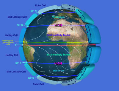
As air rises above the surface it diverges near the top of the troposphere and moves poleward. Advancing toward the pole the air begins to converge at between about 25 and 35 degrees north and south latitude. You can easily demonstrate why this occurs by placing your fingers on the lines of longitude printed on a globe. Move your hand poleward keeping your fingers on the longitude lines. Notice how your fingers converge as your hand moves poleward. A similar thing happens to the air. Upper air convergence and radiational cooling cause the air to subside in the subtropics. As the air reaches the surface, atmospheric pressure increases forming the subtropical highs. The subtropical highs have a significant impact on the climate of the earth as well as a being a force behind the major ocean currents. Subsidence towards the surface prevents the uplift of air needed to produce large scale condensation, cloud formation and precipitation. In addition, compressional heating of the air as it descends causes a drop in the relative humidity of the air. The location of majors deserts like the Sahara Desert, coincides with the presence of the subtropical highs.
As the air subsides toward the surface it diverges outward from the center of the subtropical highs. Equatorward of the subtropical highs the winds are generally light and variable. The "horse latitudes" as called by Spanish sailors was a region where ships where often calmed for days on end. To conserve water, the Spanish conquistadors would throw horses into the sea. In the Northern hemisphere the air is turned to the right of its path as it moves outward. Equatorward of the subtropical high, the pressure gradient between the high at 30o N and the low over the equator creates the northeast trade winds. In the southern hemisphere, the air is turned to the left of its path as it diverges from the subtropical high creating the southeast trades.
At the equator, convergence occurs between the northeast tradewinds of the northern hemisphere and the southeast trade winds of the southern hemisphere creating the Intertropical Convergence Zone. The converging tradewinds form a zone of calms and weak winds with no prevailing wind direction called the "doldrums" between about 5o north and south latitude. Old sailing ships often remained calmed for days on end awaiting the winds to pick up.
On the poleward side of the subtropical highs the air heads poleward but is turned to create a westerly wind pattern between 30o N and 60o N in the Northern hemisphere. This wind belt is known as the westerlies. A similar westerly belt of winds can be found between the 30o and 60o S in the southern hemisphere.
The loss of energy at the poles creates very cold air that subsides towards the surface. This creates a dome of high pressure called the polar high. Air moving equatorward is turned in an easterly direction creating the polar easterlies. The polar easterlies collide with the westerly wind belt at about 60 N and S creating a broad belt of low pressure called the subpolar low. This is a zone of storms and migrating high and low pressure systems, the topic of the "Weather Systems" module.
The global wind and pressure belts are extremely important elements of the Earth's climate system. To a great extent, they determine the geographical pattern of precipitation. Low pressure systems promote moist conditions while high pressure tends to suppress precipitation. Global air masses ride within the global winds belts to bring moisture needed for precipitation or scorching hot temperature. The relationships between the global wind and pressure belts and the geographical distribution of precipitation is taken up in the "Atmospheric Moisture" and "Climate Systems" chapters.
Global Pressure Patterns, Precipitation, and Climate
Global pressure systems play a direct role in the geographic distribution of precipitation. This influence is especially apparent in the relationship between pressure patterns and the distribution of precipitation and climate in Africa. For the most part, there is a horizontal pattern of climates stretching from the equator to poleward of 30o N related to the location of the Intertropical Convergence Zone (ITCZ), the semi-permanent Subtropical High (STH), and cyclones of the midlatitudes.
Starting at the equator are the rainiest climates on earth, the tropical rain forest (Af) and tropical monsoon (Am). The tropical rain forest is noted to for its high, year-round rain fall that often exceeds 100 inches in a year. The copious rainfall is a product of the warm moist air masses that converge into the low pressure belt that straddles the equator and uplifted by convection. The monsoon climate in Africa, like the Asian monsoon, has a notable dry period during the low sun season. The dry period is due to the presence of the subsiding air of the subtropical high, while the wet season is due to the presence of the ITCZ and moisture-bearing trade winds along the coast.
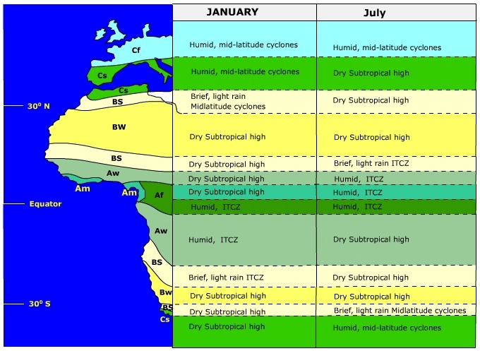
(Modified from Trewartha, Robinson, Hammond, and Horn, 1977, p. 100)
Poleward of the monsoon and rain forest climates is the Tropical Wet/Dry climate (Aw) often called the "Savanna" climate. Like the monsoon climate, precipitation is seasonal though the Tropical Wet/Dry climate receives much less on an annual basis. During the low sun season, it is dominated by the STH producing extremely dry conditions. The savanna climate is considered a transitional climate between the rainy tropical and dry tropical climates.
The Tropical Steppe climate (BS) is dominated by the STH for much of the year, though it does receive brief high-sun season rains as the ITCZ migrates into this region. The Tropical Steppe climate is considered a semi-arid climate with enough precipitation to support drought resistant grasses but not for trees. Poleward of the steppe is the Tropical Desert Climate (BW). The tropical desert climate is the driest on Earth that in some locations has virtually no measurable precipitation on an annual basis. The extreme aridity is due in part to the year-round dominance of the subtropical high.
At about 30o north latitude we encounter another zone of tropical steppe climate. Though the climatic conditions are the same, the seasonal dominance of pressure systems has reversed. During the high sun season the STH moves into this region to create dry conditions. During the winter, cyclones spawned in the midlatitudes slip into the steppe climate to bring sporadic and brief rain showers.
Finally, we reach the Mediterranean Sea where we find the Dry Summer Subtropical Climate (Cs), or sometimes called the "Mediterranean Climate". Like the steppe climate on its equatorward border, it has a dry summer/wet winter precipitation regime. However, the region receives more precipitation on an annual basis than its neighboring steppe climate.
To learn more about the effects of atmospheric circulation on our environment, proceed by: "Digging Deeper: Air Quality and Pressure Systems" or continue to the next topic.
Digging Deeper: Air Quality and Pressure System
Regions susceptible to air pollution problems result from the interaction of climatic and topographic conditions in the presence of pollution sources. Air pollution is especially prominent where high pressure dominates. Subsiding motions within an anticyclone suppress air trying to rise off the surface. Adiabatic warming of subsiding air creates a subsidence inversion which acts as a cap to upwardly moving air. Pollution problems dissipate when a low pressure system replaces a retreating anticyclone.
Los Angeles, CA is a perfect case study for the effect of climate and topography on air pollution. Topographically, Los Angeles sits in a basin with the San Gabriel Mountains to the east of the city. During the summer the subtropical high pressure cell over the eastern Pacific has migrated to its northern most limit and expanded in size. The subsiding air of the subtropical high is compressed as it descends through the atmosphere, creating a warm layer of air aloft. In addition, adiabatic heating lowers the relative humidity, preventing the development of clouds. The cloudless skies enable much insolation to reach the surface.
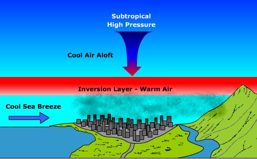
(Redrawn after Gabler et. al., 1999)
At the surface, air cooled by the cold California current comes ashore on cool sea breezes. The dense cool air sinks into the basin as it comes onto land. The mountains to the east prevent air from moving out of the vicinity of the basin. With cool air at the surface and the warm layer aloft, inversion conditions take hold. The inversion limits the height to which pollutants generated by industrial activities and motor vehicles are moved. Under cloudless skies, insolation initiates photochemical reactions in the urban atmosphere to create the infamous smog problem that Los Angeles has.