2.1.9: The Oceans
- Page ID
- 15549

It's obvious why Earth is called the "Blue Planet" as 71 percent of the surface is covered by water, 97% of which is in oceans. Oceans appeared on Earth between 3 and 4 billion years ago from which sprang life. Ancient algal formations found in the water near Australia called stromatolites are thought to have been the early source for oxygen in the atmosphere.
Oceans & Seas
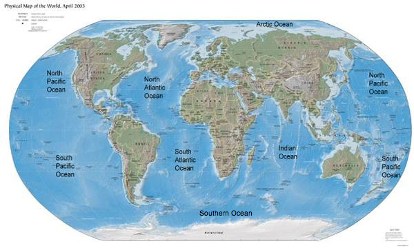
Five principal oceans the Pacific, Atlantic, Indian, Southern and Arctic comprise the "world ocean" that surround the Earth's continental land masses. The Pacific Ocean is the largest covering 166 million square kilometers (64 million square miles) of the surface with an average depth of 4200 meters (14,000 ft). At nearly half the size, the Atlantic Ocean occupies 83 million square kilometers (32 million square miles) with an average depth of 3900 meters (13,000 ft). With a similar average depth, the Indian Ocean is slightly smaller at approximately 73 million square kilometers (28 million square miles). The Southern Ocean surrounds Antarctica and was recognized in 2000 as an ocean by the International Hydrographic Organization. It encompasses roughly 20.3 million square kilometers (7.8 million square miles) with a typical depth between 4,000 and 5,000 meters (13,000 to 16,000 feet). The Arctic Ocean is the smallest covering 13 million square kilometers (5 million square miles) with an average depth of 930 meters (3250 ft). Some view the Arctic Ocean as a sea rather than ocean because of its small size.
Seas are salt-water bodies smaller than oceans and partially enclosed by land. Major seas include the Mediterranean, Baltic, Bering, Black, Caribbean, Coral, North, Red, and Yellow. Unlike inland lakes that can be salt or fresh water, there is a constant exchange of water between ocean and sea. Several inland salt lakes like the Aral, Caspian, and Dead are erroneously named "seas".
The Nature of Ocean Water
Sea water makes up the largest store of water in the hydrologic cycle. It is comprised of nearly 60 chemical substances with common salt being the most abundant, 78% of the dissolved solids. Ocean salinity varies from 32 - 37 parts per thousand. Salinity is lower near land and in the polar regions (30 ppt).
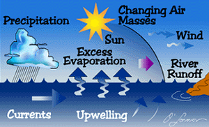
A number of factors determine ocean salinity. Salinity is lower where freshwater rivers enter the ocean. In the North Pacific precipitation exceeds evaporation thus diluting ocean water. Water is more saline in subtropical oceans where evaporation exceeds precipitation. The Atlantic ocean is the most salty while the Arctic ocean is the least.
The oceans exhibit three vertical temperature zones, 1) a surface layer of water, 2) a transition zone of decreasing temperatures with depth, and 3) the cold waters of the deep ocean. The zone of transition, known as the thermocline, is most noticeable where surface water is warmest. Polar water may have no thermocline as the surface temperature are very cold.
Learn more about the impact of human activities on ocean water by Digging Deeper: Ocean Acidification, or continue to the next topic.
Digging Deeper: Ocean Acidification
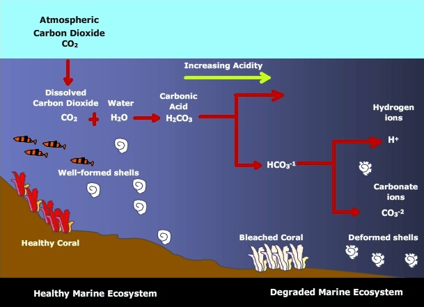
Oceans play an important role in the natural cycling of carbon dioxide through the Earth System (See: The Carbon Cycle). But the chemistry of the Earth's oceans is changing as a result of the absorption of anthropogenic carbon dioxide emissions. The ocean's absorb about 25% of the carbon dioxide released from human activities each year. The result is a decrease in pH and acidification of ocean water leading to severe consequences for ocean ecosystems.
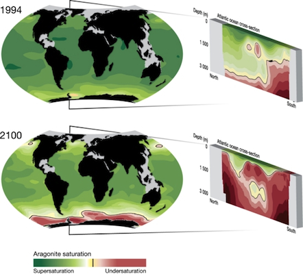
How ocean acidification happens
When carbon dioxide (CO2) combines with ocean (H2O) it forms H2CO3, carbonic acid. Most of this acid dissociates into hydrogen ions (H+) and bicarbonate ions (HCO3-1). The increase in H+ ions reduces pH and raising the acidity of ocean water. Since the dawn of the industrial revolution, which was fueled by fossil fuel burning, the pH of Earth's oceans has decreased from 8.2 to 8.1. This doesn't sound like much, but realize that pH is measured on a logarithmic scale. The .1 change represents a 30% increase in acidity. This increase is 100 times faster than any change in acidity for at least the last 20 million years. Under current emission rates, pH will fall by 0.4 between now and 2100, a 3-fold increase in acidity.
Impacts of ocean acidification
The impact of acid acidification is wide ranging and potentially disastrous for the earth system. Ocean acidification causes or is linked to various impacts on the ocean and its ecosystems. Some of these are:
- Decreasing uptake of atmospheric carbon dioxide as saturation level is approached. Like other elements dissolved in a solution, water has a saturation point beyond which its "sink function" ceases to be effective at absorbing carbon dioxide. As a result, more CO2 is left in the atmosphere to fuel global warming.
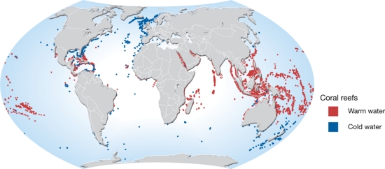
- Damage to coral reef ecosystems. Coral reefs are found in two types of ocean habitat, warm water and cold water. Warm water coral reef are typically found at shallow depths and in tropical waters. Cold-water corals are found at much deeper depths and in subtropical to high latitude oceans. Ocean acidification has been shown to hinder the calcification of deep-sea, or cold-water, corals. It is estimated that by 2100, 70% of cold-water corals will be exposed to acidified ocean water. Though excessively warm water is often the cause, acidified ocean water has been linked to coral bleaching. The whitening caused by bleaching occurs when corals lose microscopic algae within their tissues that give corals their wonderful colors.
- Slower growth rates for marine organisms with calcareous skeletons. As carbonic acid forms from the uptake of atmospheric CO2, the hydrogen ion concentration increases limiting access to carbonate ions needed to form shells.
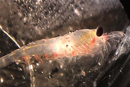
- Disruption of marine food webs. Impacts on phytoplankton and other sensitive species may disrupt marine food webs and in turn affect fisheries. Phytoplankton are organisms that float on or near the surface of water. Most are single-celled, like diatoms and dinoflagellates,and in the ocean serve as the foundation of the marine food web. Phytoplankton are the primary producers of the ocean, accounting for 95% of the ocean's primary productivity. They serve as food for zooplankton that include copepods, some species of shrimp, and larval forms of jellyfish, barnacles, mollusks, and fish. Small predators like shrimp, krill, sardines, etc feed on the zooplankton, and are in turn eaten by large predators which include birds, large fish, and marine mammals. Loss of the species at the foundation reverberates through the entire food web. Soon, fisheries important to many national economies founder resulting in a degraded marine ecosystem.
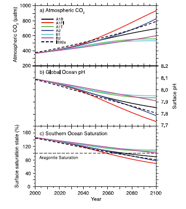
Future ocean acidification
Ocean acidification is projected to increase this century as atmospheric carbon dioxide continues to increase. The amount of acidification depends largely on future emissions as shown by the Intergovernmental Panel on Climate Change projections for various emission scenarios. The worse case scenario for ocean acidification is one in which the world continues to use carbon-based energy resources to fuel its economic, industrial, and transportation needs.
Audio Program: Acid in the Oceans: A Growing Threat to Sea Life (Courtesy NPR - All Things Considered)
The Ocean Floor
The deep-ocean floor has an average depth of 4000 meters (12,000 feet) with a significant variation in the depth. The ocean basins are cut by deep trenches and large mountains rise from the floor. The midocean ridge is the longest continuous chain of mountains on Earth winding its way along the sea floor through all the oceans. Its width average 1600 kilometers (1000 mi) with ridges rising an average of 1500 - 3000 meters ( 5,000 - 10,000 feet) above the floor. Along its spine, new sea floor is created and spreads apart by lava pouring out of rifts along the ocean ridge. Along the rugged volcanic topography of the ridge one finds dramatic undersea volcanoes called "black smokers".
Long narrow arc-shaped trenches cut across the deepest parts of the ocean floor. Trenches are found near active plate margins where earthquakes and volcanoes are common. Converging plates in subduction zones recycle rock along the ocean trenches. Ocean-flooring drilling along trenches and the midocean ridge indicates that rock is recycled over a period of 2 to 3 million years. The deepest trenches are found along the Pacific "Ring of Fire". Trenches are common along curved island arcs like the Aleutian Islands.
The vast submarine plains of the "ocean deep" are the abyssal plains. The abyssal plains cover 40% of the ocean floor with depths of 3000 - 6000 meters (10,000 - 20,000 ft). Wind deposition and volcanic eruptions have covered most in layers of brown and red clays. Some are covered with the remains of microscopic marine organisms known as ooze. The celebrated White Cliffs of Dover are uplifted ooze deposits.
Rising from the ocean floor one finds seamounts, mountains that do not reach the water's surface and typically formed from extinct volcanoes. Guyouts are flat-topped seamounts.
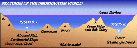
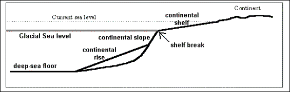
Continental Margins
The continental margins are comprised of three topographic features. The ocean floor slopes gradually upward toward the continents forming the continental rise. Approaching the edge of the continent the slope of the ocean floor steepens into the continental slope. At the top of the slope lies the continental shelf, a gently sloping platform of varying width. Along passive margins like the east coast of the United States, the continental shelf is wide. The continental shelf is much narrower along active margins bordered by mountains like that found along the west coast of the United States.