
7.12: Glacial Deposits
- Page ID
- 14366
Introduction
Here are some comments on the nature of sedimentary materials deposited by glaciers:
- It tends to be fresh. After a glacier picks up the loose preexisting material, it wears away fresh bedrock. And there’s no weathering while the material is in transport. So the material deposited beneath the glacier, or dumped at the terminus, tends to be fresh. (But the deposit itself can undergo subsequent weathering.)
- It faithfully reflects the composition of the upglacier source rocks.
- It varies widely in composition, because it reflects the composition of the bedrock directly upglacier, which of course can be anything. It consists of both mineral grains and rock fragments.
- It tends to be poorly sorted. A glacier is indiscriminate in terms of the particle sizes it carries, so deposits directly from the glacier are likely to be very poorly sorted. Glacial deposits are among the least well sorted of all sediments. But if the material is reworked by water or wind, it can end up being fairly well sorted. (But it’s still called glacial sediment if it’s recognizably related to glacial action.)
- Particle shape is sometimes characteristic: multifaceted "flatiron" shapes are common among the larger, gravel-size clasts. This characteristic shape is caused by abrasion while in successive orientations as a tool at the base of the glacier. Only some, not all, of the large clasts show this characteristic shape.
- The larger clasts are often striated, just like the underlying bedrock. Beware, however, that other agents of transport (like debris flows) can produce striations on gravel-size clasts.
Notes on Classification of Glacial Deposits
It’s important to understand that classification of glacial deposits is two-fold:
- texture of material in general
- form or geometry of deposit
Composition is typically not taken into account in classification.
There’s a partial but not nearly total correlation between these two bases for classification. It’s common to have the same textural kind of deposit involved in more than one morphological kind of deposit, and the same morphological kind of deposit showing more than one textural type—thus the need for separate ways of looking at glacial deposits. (One could argue that this could be the case for sediments in general, but usually we can’t study them together as suitably as in glacial deposits.)
Glacial Drift
Glacial sediments have long been called drift. That word dates from before the glacial theory, when it was thought that this characteristic material was deposited by flowing water (“drifted” in). Glacial drift is all material in transport by glacier ice, all deposits made by glacier ice, and all deposits predominantly of glacial origin even though not deposited directly by a glacier. Glacial drift is thus highly varied in texture, composition, deposit morphology, and origin. In the following I’ll discuss the nature of the material first, and then the deposit geometry later.
Glacial drift is usually subdivided into two major categories: till, on the one hand, and material variously called stratified drift, washed drift, or sorted drift, on the other hand (Figure 7-46). (A really good term for this second kind of drift has not yet been invented.)
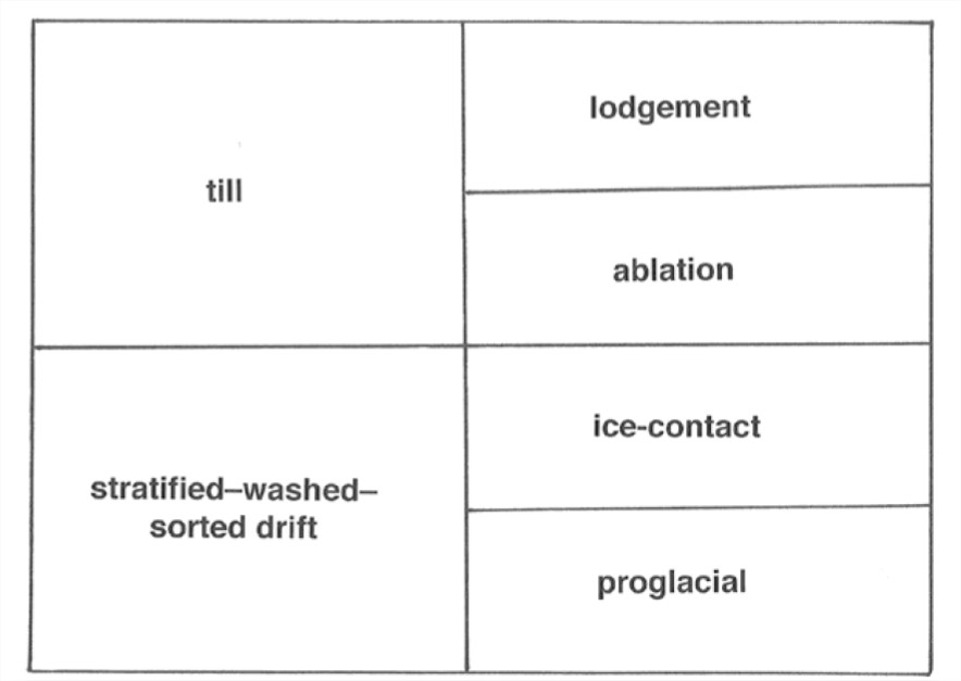
The distinction between till and s/w/s drift is basically descriptive: till is poorly sorted and largely nonstratified, and s/w/s drift is much better sorted and characteristically well stratified. But the distinction is universally viewed as having a clear genetic basis: till is deposited directly from glacier ice, without the effect of flowing meltwater, whereas s/w/s drift is material that has been picked up by flowing meltwater and redeposited somewhere else.
Till
General
Till is a genetic term applied to all unstratified and unsorted deposits made directly by or from glacier ice. The lithified equivalent of till, as seen in the ancient sedimentary record, is called tillite.
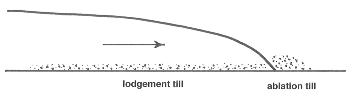
Till is subdivided in turn into lodgement till and ablation till (Figure 7-47). Lodgement till is deposited directly from the moving ice beneath the moving glacier, whereas ablation till is deposited at the glacier terminus as the ice melts and drops its load. The distinction between lodgement till and ablation till is thus a genetic one.
Lodgement till
Classic lodgement till is a very characteristic sediment:
- The particle size ranges from large boulders continuously down to clay- size material (mainly rock flour: ground-up very-fine-grained mineral material) Tills are often described as boulder clays.
- Typically the larger clasts “float” in the matrix, so the sediment could be called matrix-supported.
- There’s usually no stratification: till is typically a structureless deposit.
- Often there’s a subtle statistical preferred orientation, or fabric, especially of the larger clasts; the long axes tend to be oriented parallel to glacier flow.
- The sediment tends to be cohesive even if it’s young; the degree of compaction is such that often the stuff has to be dug with a pick instead of a shovel. Tills, even young ones, are often lithified enough to be jointed.
- It has low porosity and very low permeability.
In terms of genesis, it seems clear that till like that described above is deposited particle by particle from the base of an active glacier. Till known or thought to have been deposited in this way is called lodgement till; remember that this is a genetic term.
Apparently it’s common in the peripheral parts of an ice sheet for the glacier to be overloaded at its base, so instead of the glacier picking up material, it’s depositing material. But the relative importance of the various deductively reasonable mechanisms of lodgement are largely unclear.
Here are a few comments on the mechanics of subglacial deposition. Three mechanisms of subglacial deposition can be envisioned:
- Pressure melting at the base of the sediment-laden ice releases particles at a rate faster than the rate at which comminution by abrasion plus removal by meltwater can operate, and the excess particles left beneath the ice are plastered onto the depositional surface.
- Plastering happens because the frictional drag on sediment particles in movement over the sediment becomes equal to the tractive force of the glacier ice. This might happen where the ice is decelerating and the friction is decreasing.
- Gradual reduction of basal ice velocity leads to shearing over successive layers of ice–debris mix at the base, and then the water is eventually removed by melting.
There have been just a few direct observations of lodgement processes at the base of a glacier. These indicate that at least the first two processes actually happen. And there’s no reason to believe that the third can’t happen as well.
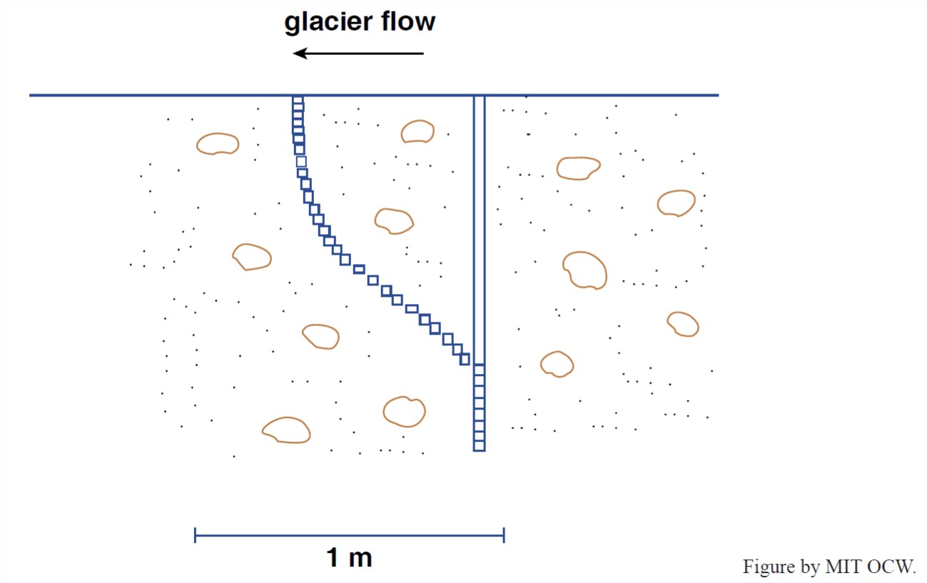
Another important thing about lodgement till is that under some conditions it can undergo flow by shearing after it’s deposited. The moving glacier above the sediment exerts a shearing force on the upper surface of the deposit, and if the shearing force exceeds the shear strength of the material, the till flows. Here’s a qualitative treatment of the forces involved in such flow.
The shear strength of a continuous granular medium like till is a reflection of the frictional resistance the material affords to shearing. Think of the resistance to shearing as a matter of friction: the frictional stress, which tends to make the material shear along shearing planes, can be viewed in the classical way as the product of the normal stress exerted on the plane of shearing and the coefficient of sliding friction. The high water content together with the low permeability of typical lodgement till beneath the glacier means that the effective normal stress on the shearing planes is greatly reduced by the water pressure in the pores, because the water pressure lessens the particle-to-particle contact forces. If that doesn’t make sense to you, just think in terms of buoyancy or submerged weight: fill a drinking glass with loose sand and think about how much the grain- to-grain contact forces are lessened when you fill the glass with water interstitial to the sand grains.
The slow flow of subglacial lodgement till has actually been observed directly in a few cases. All you have to do is drive a tunnel under the base of the ice (and keep it open!), and then drive a segmented rod down into the till. Come back sometime later, excavate the rod, and see how its little segments have moved in the downglacier direction. Figure 5-48 shows an actual measurement of this kind.
Ablation till
The other kind of till, called ablation till (also a genetic term, remember) is easier to understand. It’s deposited right at the terminus of the glacier, in the process of ablation there, not underneath the glacier. This is one of the things that can happen to the load of the glacier that’s delivered all the way to the terminus rather than being lodged beneath the glacier.
Although I’ve never seen any definitive pronouncements, my guess is that more sediment is delivered to the terminus than is extracted from the glacier from below, upglacier of the terminus. This material is simply released from the glacier ice as the ice melts—hence the term ablation till.
The important thing about ablation till is that it’s not as rich in very fine material as lodgement till, because the liquid water melted out of the glacier tends to carry that material away in suspension, leaving behind the coarser material, of gravel, sand, and silt size (along with some fraction of even the finest material as well). So ablation till is more friable and easier to dig than lodgement till. It’s not difficult to tell the two apart in this way.
You may be thinking that what I’ve said about ablation till makes it seem closely related to, or indistinguishable from, what I called washed drift. The important point is that the material that was deposited to form the ablation till—what’s there for you to see—was deposited directly from glacier ice; only the finest fraction is winnowed by the meltwater and deposited somewhere presumably far away. Of course, there are likely to be gradations between ablation till and washed drift, depending on how much meltwater happens to be around and flowing in the given locality, and therefore on how much of the coarser material is transported and redeposited.
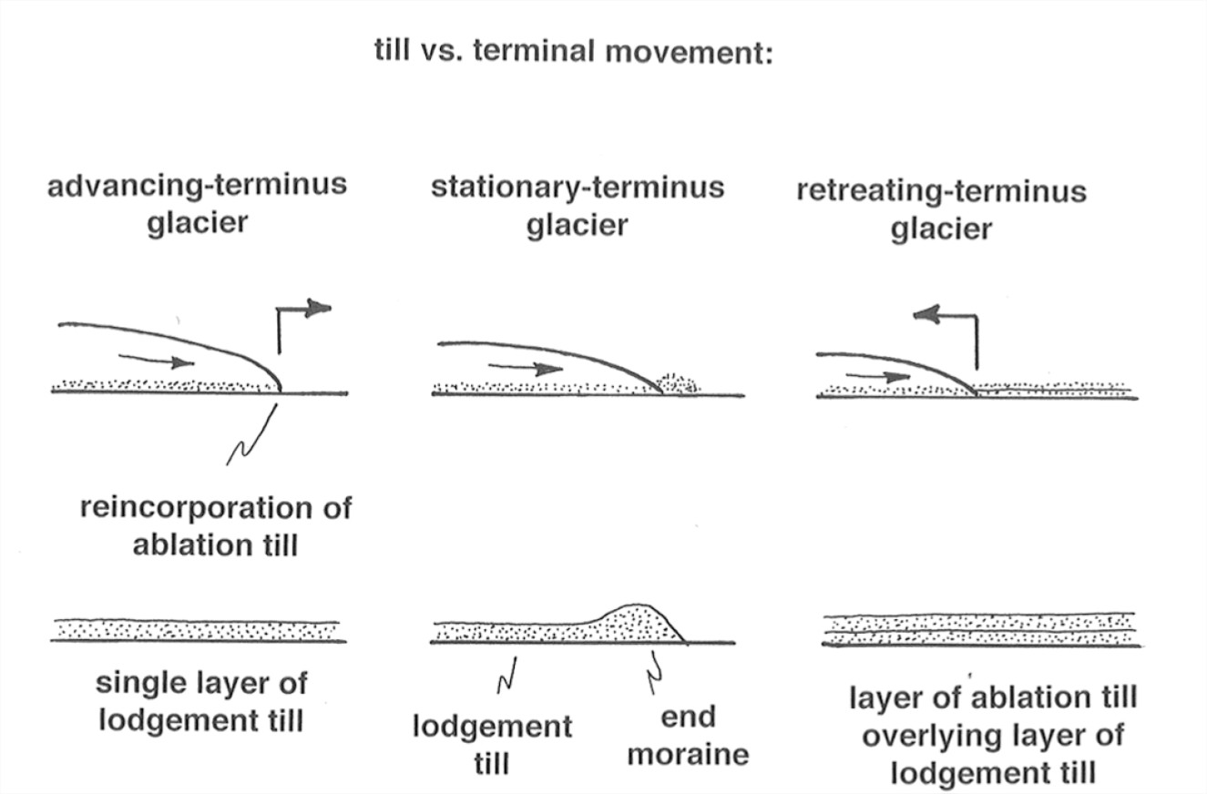
Two-Layer Till Sheets
From what was said above about the deposition of till, it should make sense to you that till typically appears as extensive sheets and blankets that mantle the landscape continuously or semicontinuously. (The mantle of till tends to be thicker in valleys than on hills, and thicker on the lee sides of hills than the stoss sides.) The thickness of till sheets ranges from less than a meter to many meters, and in some cases even tens of meters. Till sheets take on a wide and interesting variety of geometrical forms; I’ll elaborate in a later section.
Commonly, though not nearly always, one sees a two-layer till sheet: a lower layer of lodgement till, and an upper layer of ablation till. The upper layer of ablation till tends to be spottier and less continuous than the lower layer of lodgment till, but the two-layer structure is nonetheless characteristic.
It’s easy to understand how the two-layer arrangement of till comes about (Figure 5-49). As the glacier advances, it’s likely to form an underlying sheet of lodgement till. Then, during retreat, ablation till deposited at the retreating terminus of the glacier is spread backward as a sheet across the underlying sheet of lodgement till.
The Morphology of Till Sheets
When till sheets are viewed morphologically or topographically, they are usually termed ground moraine (note the without-the-article usage).
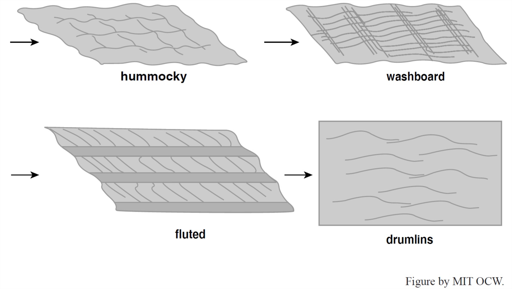
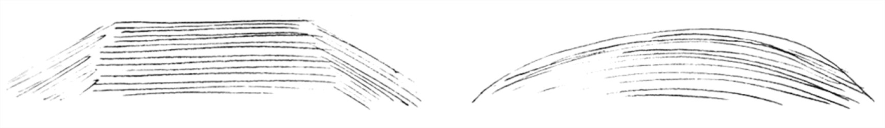
The topography of ground moraine varies widely (Figure 7-50). Often one sees a fairly regular series of ridges and furrows oriented parallel to the direction of ice flow. The relief of these ridges and furrows varies from less than a meter high and only a few hundreds of meters long, to giant features, up to a few tens of meters high and a few tens of kilometers long. The ridges are strikingly straight and parallel. This kind of topography can best be appreciated from the air or on air photos. Ground moraine showing such ridges and furrows is called fluted moraine or fluted ground moraine.
How is the ridge-and-furrow topography produced? Most theories rely on lateral flowage of till beneath the glacier, somehow. The idea here is that till moves laterally in a semiliquid or plastic state subglacially in response to subglacial hydrostatic pressure field. For example, low pressure in the lee of boulders or rock knobs should produce flow into that area, and these low-pressure areas might tend to extend themselves downstream. All such explanations are highly speculative.
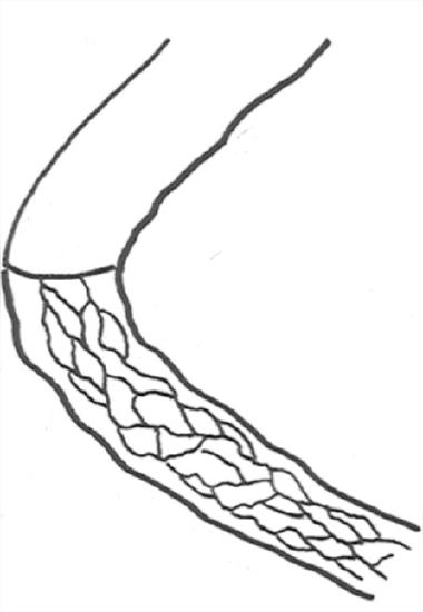
Drumlins are another very characteristic kind of ground-moraine topography. You’ve all seen drumlins: glacially streamlined hills, ideally almost half-ellipsoidal in shape. Drumlins are found in large numbers in certain areas, called drumlin fields. Drumlins can be cored by either till or bedrock hills. Often the drumlin consists of a streamlined tail of till extending downstream from a bedrock knob. There’s a whole spectrum of features intermediate between discrete and rather blunt drumlins to long and regular longitudinal ridges and furrows. Often what are called drumlins are very elongated hills that might better be called longitudinal ridges.
A great many theories on the origin of drumlins has been proposed, but none of them has become really widely accepted. The problem is the classic one that we can’t observe them in the process of formation. Actually drumlins may be a polygenetic phenomenon. The usual approach is to invoke some kind of depositional response to subglacial pressure differences, either by flowage of till or preferential lodgment. Clearly a dynamical instability of some kind must be involved, or else the till surface would remain planar. But this kind of approach doesn’t seem to be appropriate or necessary to explain rock-cored drumlins with just a veneer of till, especially if the drumlins are more or less isolated.
Just to confuse you further, let me point out that some kinds of ground moraine show transverse topographic elements. Such ground moraine is usually called ribbed moraine or washboard moraine. It’s clear that such topography is produced subglacially, not at the glacier terminus. But again, understanding is in a poor state: there are lots of theories, all of them speculative.
Finally, it’s only fair to point out that much ground moraine shows no strongly organized topographic elements, just a seemingly random collection of high and low areas, often rather subdued. Apparently in many cases none of the various mechanisms leading to flow-parallel or flow-transverse features are at work.
Stratified Drift
Introduction
The term stratified drift refers to glacial drift that has been reworked by glacial meltwater and then deposited either in direct contact with glacier ice or at some point more or less far away from the glacier, in a wide variety of depositional environments. In a kind of order-of-magnitude sense, stratified drift is just as common and important as glacial till.
The term stratified drift is not an especially good one. What’s called stratified drift is indeed usually prominently stratified, but the term doesn’t do well at capturing the essence of the stuff. Alternative terms, perhaps somewhat better but not a lot better, are sorted drift and washed drift.
Here are some miscellaneous important points about stratified drift:
• It’s mostly sand or sand plus gravel; the fines are carried away in suspension.
• It occurs in large to small but basically isolated deposits. Sometimes it’s in two-dimensional belts, but it’s never in extensive sheets like till sheets. The main reason is that streams are by their nature localized.
• Stratified drift commonly forms deposits with considerable relief, so it’s often seen as hills.
• It almost always shows excellent and striking stratification, because it’s laid down by flowing water stratum by stratum, and conditions of deposition usually vary with time.
• It commonly shows cross-stratification on various scales, because of the existence of ripple and dune bed configurations under a wide variety of conditions of flow and sediment.
• It commonly shows deformation features, because it’s often deposited against steeply sloping surface of ice, and, when the ice inevitably melts, the sediment slumps and slides.
• It’s an important source of sand and gravel for making concrete (in glaciated regions that is; in nonglaciated regions, sand and gravel is usually a lot harder to come by).
Watch for sand and gravel pits and quarries for examination of cuts through stratified drift. The trouble is, the good viewing doesn’t last for long.
In this section I’ll deal mostly with the mechanics of transport and deposition of stratified drift, and the characteristic form or geometry of the drift deposits.
Classification
It’s not easy to classify stratified drift, because there’s basically a continuous gradation among the various types. But there are some characteristic types, and we’ll deal with these.
There are two major categories of stratified drift:
• ice-contact stratified drift: deposited in direct contact with, or at least in the immediate proximity, of, glacier ice, active or inactive.
• proglacial drift: drift that is carried out well beyond the glacier terminus by flowing water. This passes over into sediment that is not recognizably of glacial origin.
Ice-Contact Stratified Drift
First off, I want you to have two rather different mental pictures of a retreating glacier, which is ultimately going to leave the stratified-drift deposits we see (Figure 7-51). I’ll give call two contrasting modes active-ice retreat and stagnant-ice retreat. (These terms are expressive but not really official.)
• active-ice retreat: there’s a fairly steep ice slope in the downglacier area; the ice flows actively all the way to the terminus; there’s a well defined terminus even though the glacier is retreating; meltwater discharges directly off or from the glacier and forms a well defined stream, except when the terminus lies in a glacial lake.
• stagnant-ice retreat: the glacier surface has a fairly gentle slope near the terminus; excessive ablation reduces the thickness of the glacier over a substantial distance, thereby giving rise to a broad belt at the downstream end of the glacier where the ice can no longer flow; the dead melting ice then sits around over a large area, and the active terminus is now located far upglacier; meltwater streams flow between, around, under, and over this dead ice, depositing stratified drift, and the dead ice sheds sediment as it melts as well.
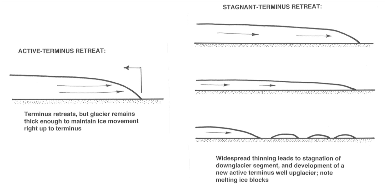
An important point: most retreating glaciers in modern times show active-ice retreat rather than stagnant-ice retreat, either because they are valley glaciers or outlet glaciers, which usually remain well integrated even during retreat, or, if they are ice sheets with broad terminus fronts, they calve into the ocean. But stagnant-ice margins seem to have been very common at times of rapid ice-sheet retreat at the end of the Pleistocene, because there were widespread ice sheets on flat, low land in temperate regions. So we suffer somewhat from a lack of highly realistic modern models for deposition of the stratified drift we see resting on the landscape today.
Think first about deposition of sediment in meltwater streams before those streams leave the glacier.
• supraglacial streams could be carrying sediment that’s deposited as a bed and then abandoned when the stream disappears; the sediment would then eventually let down onto the land surface by melting. Apparently this is not common.
• englacial streams: same thing.
• subglacial streams: these are by far the most important in carrying sediment, both because streams tend to migrate to the base of the glacier and because that’s where most of the sediment is carried by the glacier.
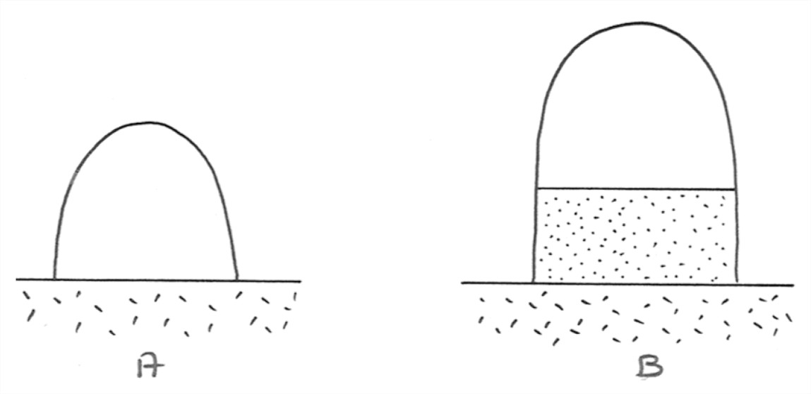
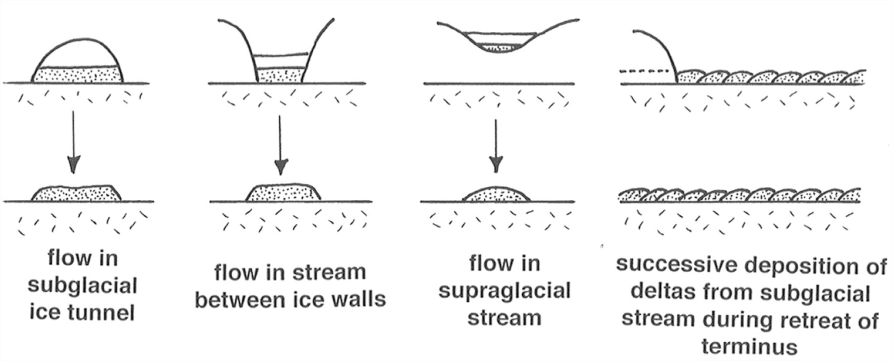
Subglacial streams certainly deposit a lot of sediment as they leave the glacier. But how about deposition upstream of the glacier terminus? There may or may not be deposition there, depending upon the particular relationship between sediment load and carrying capacity. Figure 7-52 shows two possibilities. Sketch A shows a subglacial stream with uniform transport capacity; all the sediment is carried through over bare rock, and no sedimentary record of the tunnel remains after melting of the glacier. Sketch B, however, shows a situation in which sediment transport rate decreases downstream for some reason, to leave a deposit on the floor of the tunnel. In this case, upmelting of the tunnel roof is likely, to make room for the deposit as well as the flow. A sediment ridge that follows the course of the stream is left after the glacier melts.
Remember that flow in subglacial tunnels is mechanically like pipe flow, in that there’s likely to be no free surface, except very near the glacier terminus or at times of unusually low meltwater discharge. The floor of the tunnel is either bedrock or a sediment bed, and the walls and roof are of glacier ice.
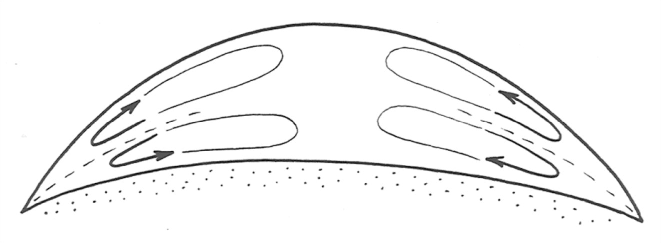
What does the cross section of the subglacial flow tunnel look like? A natural first guess would be semicircular, with a horizontal planar floor. But if there’s a full bed of sediment, it’s possible for the floor to be either concave upward or convex upward instead of planar (Figure 7-53). The meager evidence from the exhumed record of ice-tunnel deposits suggests that the sediment bed is planar or convex upward, because the stratification overall tends to be as shown in Figure 7-54.
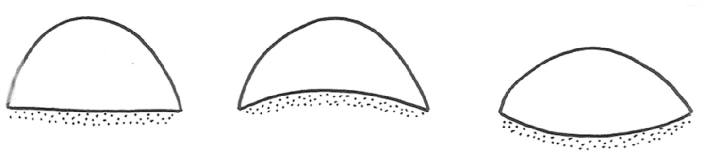
There’s a problem with this interpretation, however, because we never have direct independent evidence that the flow was really in a closed conduit. What about the possibility that the stream was flowing open to the sky in a canyon between two ice walls? That would always lead to a transversely horizontal bed rather than a convex-up bed.
One can account hydrodynamically for a transversely arched bed by appealing to secondary circulations in the flow (Figure 5-55). Such secondary circulations are known to be present in closed conduits of noncircular cross section. There are various theories on the origin of such secondary circulations, but they are not yet well understood. The circulation pattern shown in Figure 7-55 would lead to a component of sediment movement on the bed from the walls to the center, until an equilibrium transverse profile is reached in which there’s a balance between this tendency toward upslope transport and the pull of gravity back down the slope toward the corners of the cross section.
Deposits of the kind formed in ice tunnels are called eskers, a nongenetic term for any long and more or less isolated ridge of stratified drift, oriented at a small angle to the overall direction of ice flow, and presumably deposited by meltwater beneath or at the terminus of the glacier. Most eskers seem to have been deposited by meltwater streams either within the glacier, as discussed above, or as they emerge from beneath the glacier.
Eskers have rather variable features, probably reflecting a polygenetic origin (Figure 5-56). Here are some common characteristics of eskers:
• kilometers to well over 100 km long
• up to a few tens of meters high, and up to a few hundreds of meters wide
• either flat-topped or arched
• almost always all sand and gravel, well stratified; no till
• the sediment is often slumped at the margins
• often sinuous, like streams
• sometimes show tributaries and branching
• sometimes pass over bedrock divides (by as much as 200 m!) at the lowest saddle point
• sometimes end in what look to be fans or deltas
• show evidence of high-velocity flow
Many, maybe most, eskers seem to have been deposited by subglacial streams in closed flow; this accounts well for their passing over bedrock divides, for the arched bedding, and for the existence of tributaries. But of course an open-to-the-air esker formed on glacier ice could have been let down onto the bedrock divide by melting of the ice.
Many, but certainly not most, eskers must have been deposited at the downstream end of a meltwater stream where the stream reached the glacier terminus. The long length of the esker is then accounted for by year-by-year shifting of the site of deposition upglacier, as the terminus retreats. Some eskers are beaded (that is, they consist of a chain of closely spaced mounds of glacial deposits), and this mode of origin accounts well for the beading. Keep in mind that whatever the mode of origin the long length of eskers is accentuated by the retreat of the glacier.
Aside from eskers, many kinds of deposits are left by melting of ice at the terminus of a retreating glacier. These might generally be called ice- disintegration deposits. These are suites of interrelated but distinctive depositional features produced by wasting of the thin, stagnant, marginal part of a glacier, mostly by separation of the ice into isolated masses. The marginal zone of the glacier in which such features are produced might be as much as ten kilometers wide. Instead of being carried to an active terminus, the drift accumulates by various processes associated with running water, in channels or in lakes, and in various positions relative to the melting ice: in channels or openings between or beneath ice blocks, and over the surface of wasting ice.
The surface morphology of these deposits varies widely. There’s a mostly continuous spectrum or gradation of named features: kames, kame terraces, kame deltas, collapsed masses, and eskers (already discussed). All of these can be observed forming today near the termini of glaciers that are retreating in an inactive-terminus mode. One of the best examples is the Malaspina piedmont glacier in Alaska.
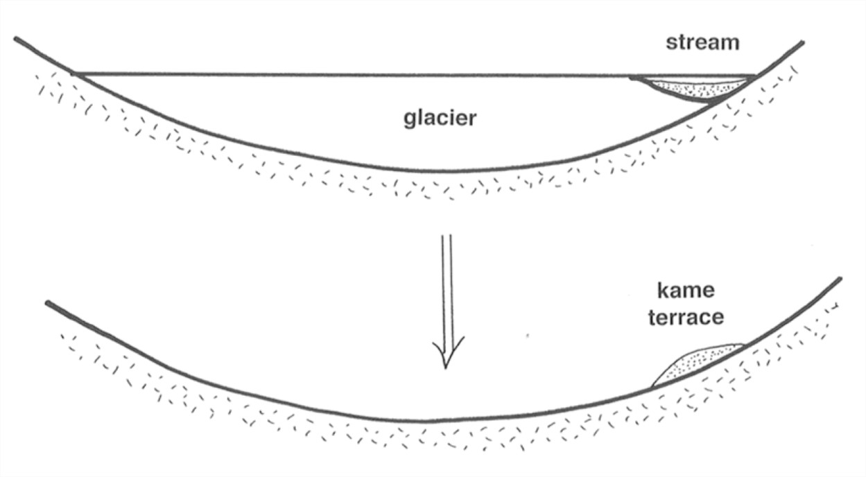
Kame terraces. In areas of active meltwater production in valley glaciers, meltwater streams often flow down the valley along the sides of the glacier. This often leaves linear deposits of stratified sand and gravel on the bedrock slopes of the valley after the glacier melts (Figure 7-57). Often these deposits are at more than one level, as a function of different stillstands of the terminus. It’s easy to confuse kame terraces with stream terraces in a nonglaciated valley.
Kames. The term kame is used for a whole variety of hills, knobs, and ridges (positive relief forms), more or less isolated from one another, of stratified sand and gravel deposited against or adjacent to wasting stagnant ice (Figure 5-58). The sediment may be derived in part from the adjacent ice itself, but the larger kames are probably formed by deposition of sediment carried from upstream by meltwater streams. Kame deposits are characteristically in part deformed, because of the collapse of sediments when the supporting ice melts away.
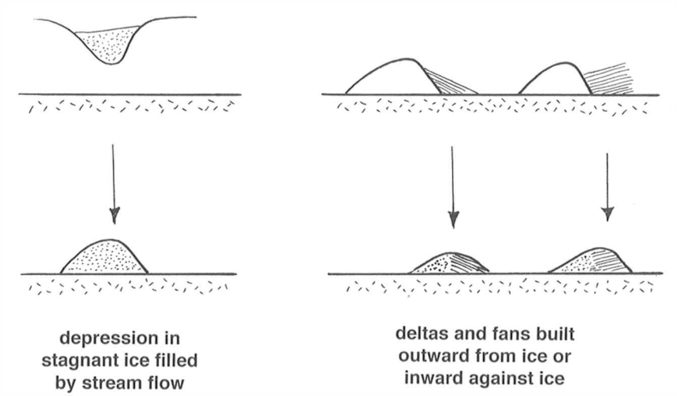
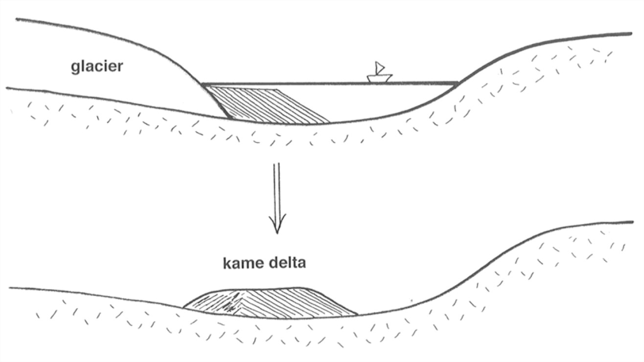
Kame Deltas. Small glacial lakes are common right next to melting glacier ice, because of local damming of meltwater drainage by either the ice itself or sediment deposited by the ice. Streams flowing between, or from the surfaces of, the melting ice masses tend to deposit deltas in the lakes. After the ice melts, the delta forms an isolated and often flat-topped mass of sediment (Figure 7-59).
Collapsed Masses. Another common ice-disintegration feature, for which there is no very felicitous term, consists of irregular masses of sediment deposited on top of wasting ice and then let down onto the land surface as the ice melts. The so- called collapsed masses tend to be blanketlike, but they are highly varied, with sharp variations in thickness. This is sort of a “wastebasket” category.
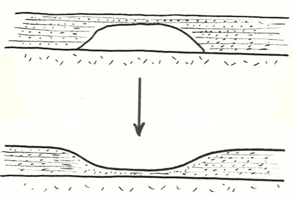
Kettles. Kettles are depressions formed when a thick layer of drift is deposited around or over an isolated ice mass and then the ice later melts (Figure 7-60). If the groundwater table later lies above the floor of the depression, the kettle has a lake within it, called a kettle lake. Kettles often are present in large numbers in areas of outwash plains; such an outwash plain is called a pitted outwash plain.
Proglacial Drift
Proglacial drift is drift deposited in various ways, by water or even by wind, more or less far removed from the glacier. The idea that proglacial drift is abundant makes sense. Look at a typical active warm glacier. There’s abundant meltwater, so large meltwater streams originating well upglacier from the terminus are important during the melting season. These streams characteristically carry high sediment loads. In such situations, most of the drift deposited by the glacier is deposited downstream from the glacier terminus. This happens whether the glacier is advancing, retreating, or stationary; if the glacier is advancing, then the glacier later overrides some of its own proglacial drift. Here are the important kinds of proglacial drift:
• outwash (glaciofluvial)
• lake deposits (glaciolacustrine)
• marine deposits (glaciomarine)
• loess (wind-blown silt)
• sand dunes (usually reworked outwash)
Glaciofluvial deposits (these are also called glacial outwash)
• Mainly sand and gravel; fine material (silt and clay) is either carried farther downstream into areas not recognizably glacial, or blown away by the wind
• Essentially fluvial in nature; channel pattern and sedimentary structures are not directly or recognizably glacial
• Typically shows rapid downstream decrease in grain size, because of overall aggradation
• Outwash streams are typically braided (factors: high sediment load; no bank stability)
The typical form taken by outwash is a fan or cone of fluvial sediment, deposited with the apex or head at the ice margin. The reasons for fan development are basically the same as for alluvial fans in nonglacial situations: abrupt decrease in gradient as the stream leaves the glacier and abrupt relaxation of channel constraints leads to decrease in capacity and therefore deposition. Outwash deposits tend toward two distinctive forms:
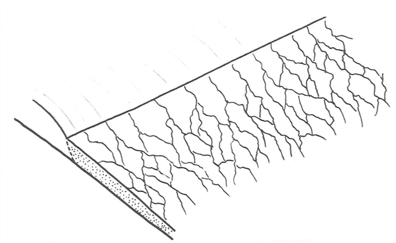
• Outwash plains: broad linear front, many outwash streams, series of coalescing fans. This leads to deposition of a broad wedge or blanket, thinning and fining away from the glacier (Figure 7-61). Also called a sandur, from the Icelandic (plural: sandar). One of the best sandar is at the margin of Vatnayökull, the largest ice cap in Iceland.
• Valley trains: braided outwash filling a glaciated valley downstream of an active valley glacier (Figure 7-62).
Commonly where both meltwater and drift are very abundant (as in wasting of a warm ice sheet in the Pleistocene), the outwash plain or fan is built up to be so thick that it is built headward over the terminus of the glacier itself and merges with ablation moraine. Often it buries stagnant ice near the terminus, leading to a pitted outwash plain as the buried ice melts. Earlier end moraines are often buried as well. This is well displayed on Cape Cod and Long Island.
Glaciolacustrine Deposits
Glaciers create three kinds of lakes:
• glacier-margin lakes dammed by the ice itself (short-lived)
• glacier-margin lakes dammed downstream by earlier-deposited glacial sediment (longer-lived but still temporary)
• bedrock depressions made by glacial erosion, later filled with water (long-lived)
Sediments deposited in glacier-margin lakes are very common, because valleys are dammed by ice or by ice-disintegration deposits.
• Probably more common during retreat that advance
• Invariably temporary, because ice dams melt soon, and glacial-sediment spillways are degraded by erosion
• Range in size from very small and lasting only years, to enormous, lasting thousands of years.
How does one explain the relatively long lives (some thousands of years) of some glacier-margin lakes? If the retreating glacier forms a long-term but moving dam in a valley, and drainage is over a rock divide, the lake remains either until the ice melts or until a sediment-formed divide is cut to the level of the bedrock spillway. Example: Glacial Lake Hitchcock in central Connecticut and Massachusetts.
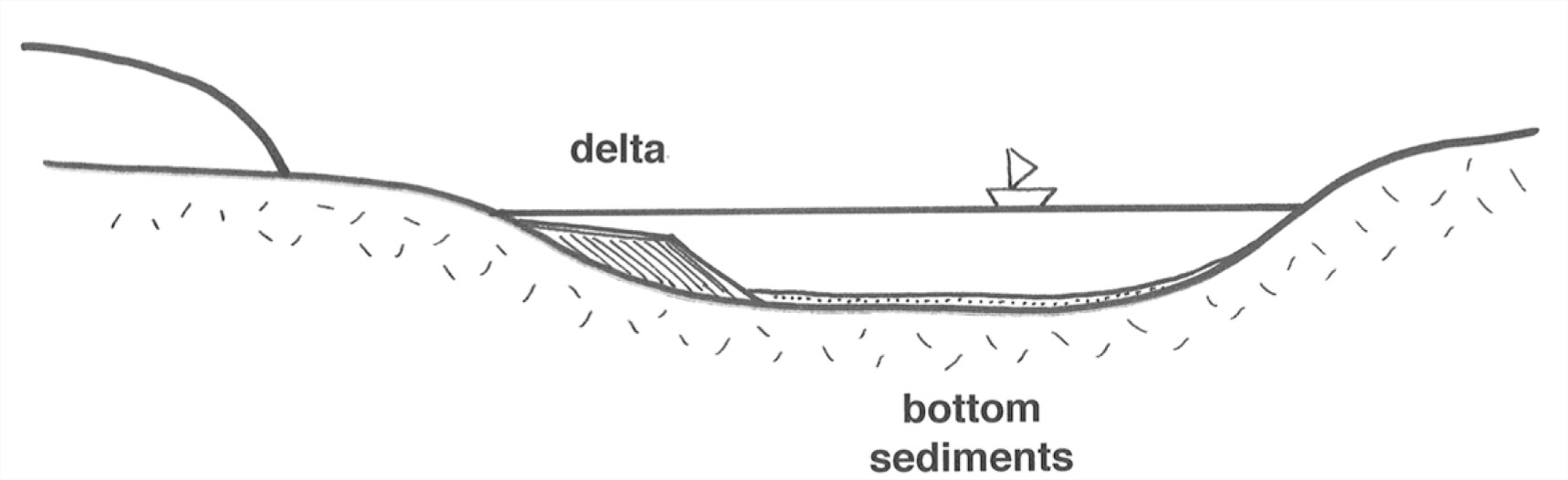
Some points about sedimentation in glacial lakes (Figure 7-63):
• Deltas of coarse sediment are common
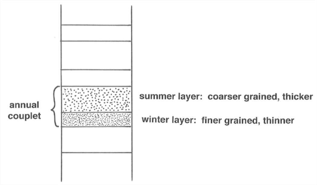
• Varves (annual coarse–fine couplets deposited on the lake bottom) are formed by differences in summer and winter suspended-sediment deposition (Figure 5-64).
• Dropstones are possible, from floating ice derived from the glacier.
Loess
The term loess is used for blankets of wind-deposited silt on the land surface. Much but by no means all loess is derived from wind erosion of broad outwash plains marginal to Pleistocene ice sheets. Some is derived also from extensive wind erosion in large deserts, not associated with glacial deposits.
Loess is unconsolidated to semiconsolidated (by slight to moderate simple cementation), and usually buff to yellow to tan in color, reflecting an oxidized state. It is unstratified to only vaguely stratified. It has the interesting property of standing in vertical slopes even though it’s easily dug with a shovel (interlocking angularity of grains, plus slight cementation?), and sometimes it even shows columnar jointing. It consists of relatively well sorted and angular grains usually in the fine silt to coarse silt range (average grain size 0.01–0.05 mm). Quartz is usually the dominant mineral. The lack of stratification is probably due to bioturbation by plants and animals, together with the relative uniformity of supply.
Loess forms blankets from less than a meter to many tens of meters thick (over 200 m in the central parts of China). Thickness is well correlated with grain size. In North America, loess is widespread in east-central to west-central US (Kansas, Nebraska, Iowa, Missouri, Wisconsin, Illinois, Indiana, Kentucky, Ohio) and also the Pacific Northwest. Coverage in North America: 1.6 x 10⁶ km2.
Glaciomarine Deposits
Icebergs produced by calving of large glaciers into the ocean often contain abundant drift, if the glacier is an active warm-based glacier. As the icebergs drift in the ocean and melt, they release this load, which settles to the sea floor along with fine sediment derived from elsewhere.
Glaciomarine deposits are characteristically well stratified but poorly sorted at the same time. The good stratification presumably comes about by annual and longer- term fluctuations in sediment supply from the icebergs. A distinctive feature of glaciomarine deposits is the presence of dropstones: unusually large iceberg- derived clasts which bow down the sediment upon impact and which are then buried by later strata that arch over the dropstone.
READINGS
Benn, D.I., 1998, Glaciers and Glaciation. Oxford University Press (one of the best recent books on glaciers and glacial geology)
Flint, R.F., 1971, Glacial and Quaternary Geology. Wiley, 892 p (the classic book, outdated but never surpassed in its excellence)
Patterson, W.S.B., 1994, The Physics of Glaciers, Third Edition. Pergamon, 480 p. (the source on the physics of glaciers most accessible to the nonspecialist)
Strahler, A.N., 1966, A Geologist’s View of Cape Cod. The Natural History Press, 115 p. (a small, readable book, old but still good, that deals in part in a very engaging way with the glacial geology of Cape Cod; long out of print)
Sugden, D.E., and John, B.S., 1976, Glaciers and Landscape. Arnold, 376 p. (a good but aging source, not highly technical)