6.4: The Water Balance of Lakes
- Page ID
- 13483

\( \newcommand{\vecs}[1]{\overset { \scriptstyle \rightharpoonup} {\mathbf{#1}} } \) \( \newcommand{\vecd}[1]{\overset{-\!-\!\rightharpoonup}{\vphantom{a}\smash {#1}}} \)\(\newcommand{\id}{\mathrm{id}}\) \( \newcommand{\Span}{\mathrm{span}}\) \( \newcommand{\kernel}{\mathrm{null}\,}\) \( \newcommand{\range}{\mathrm{range}\,}\) \( \newcommand{\RealPart}{\mathrm{Re}}\) \( \newcommand{\ImaginaryPart}{\mathrm{Im}}\) \( \newcommand{\Argument}{\mathrm{Arg}}\) \( \newcommand{\norm}[1]{\| #1 \|}\) \( \newcommand{\inner}[2]{\langle #1, #2 \rangle}\) \( \newcommand{\Span}{\mathrm{span}}\) \(\newcommand{\id}{\mathrm{id}}\) \( \newcommand{\Span}{\mathrm{span}}\) \( \newcommand{\kernel}{\mathrm{null}\,}\) \( \newcommand{\range}{\mathrm{range}\,}\) \( \newcommand{\RealPart}{\mathrm{Re}}\) \( \newcommand{\ImaginaryPart}{\mathrm{Im}}\) \( \newcommand{\Argument}{\mathrm{Arg}}\) \( \newcommand{\norm}[1]{\| #1 \|}\) \( \newcommand{\inner}[2]{\langle #1, #2 \rangle}\) \( \newcommand{\Span}{\mathrm{span}}\)\(\newcommand{\AA}{\unicode[.8,0]{x212B}}\)
Lakes have many sources of both inflow and outflow. The main sources of inflow are:
- streams
- precipitation onto the lake surface
- ground water
The main sources of out flow from a lake are:
- streams
- evaporation from the lake surface
- groundwater
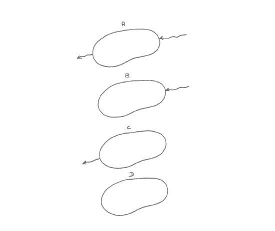
Various configurations of streams are possible:
- Stream or streams flow in, stream flows out (Figure 4-3A). Usually only one stream flows out. In this kind of configuration the stream can be viewed as simply a fat place along a river. This is the most common kind of lake.
- Stream or streams flow in, no stream flows out (Figure 4-3B). The loss is made up by groundwater outflow and/or net evaporation. This is common in arid and semiarid regions; the streams are usually ephemeral. Lakes like this tend to be playa lakes. The Great Salt Lake is a good (and large) example.
- Stream flows out, no stream flows in (Figure 4-3C). The lake is fed by groundwater, usually not just by precipitation.
- No stream flows in, no stream flows out (Figure 4-3D). The lake is both fed and drained by groundwater movement. Lakes like this are common in glaciated areas underlain by a thick mantle of highly permeable glacial sediment, as on Cape Cod.