
8.3: Orogenesis, Faults and Earthquakes
- Page ID
- 2280

Orogenesis is the term used for mountain building. A common geologist joke is that ‘subduction leads to orogeny.’ Orogenesis is often the byproduct of a continent-ocean subduction zone, where a volcanic belt is formed (see above). Orogenesis can also occur when continental plates collide with other continental plates (such as the Himalayas), or when ocean plates collide with ocean plates, forming island arc volcanoes (again, see above). However, not all mountain belts are the result of active plate collisions. The Appalachian mountains of the eastern USA are between 250 and 300 million years old. They are a scar of an old continental collision that created the super continent of Pangaea.
When plates collide, one plate is not neatly pushed beneath the other. Significant forces are exerted on the crust, causing it to bend and deform. This bending can result in ‘folded landscapes.' Often the crust of the earth will be pushed so hard that it will break along a zone of weakness or maximum pressure. This is how faults are formed. Faults generally come in clusters, as a large force is exerted over a large area, the earth will release the pressure along a fault zone.
Faults can be classified into three types, based on the forces and the direction of movement. The stresses in the earth can be resolved into three mutually perpendicular directions: vertical (Sv), maximum horizontal (Shmax) and minimum horizontal (Shmin). Faulting occurs in the direction that the forces are the weakest.
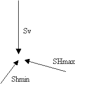
- When the vertical stress (Sv) is the greatest, then normal faulting occurs. The vertical force (gravity) basically pushes one part of the crust down to relieve stress at the zone of weakness. This puts younger rocks on top of older rocks.
- When the vertical stress is the least, then thrust, or reverse faulting occurs. The vertical force has the lowest resistance, so the tension is released by pushing older rocks on top of younger rocks.
- When the vertical stress is the intermediate stress, (SHmax is the greatest, and Shmin is the least), then strike-slip faulting occurs. In strike slip faulting the two sides of the fault do not move up or down, but rather right or left. The direction of the fault movement is denoted as ‘right lateral’ or ‘left lateral’.
When tension is suddenly released on a fault and the earth moves in one of the manners described above, an earthquake occurs. The place on the fault where the energy was released is termed the epicenter. The earth is literally covered with faults. Most faults are very small (some less than 10 meters long), and most are either inactive, or release energy in such small increments that we do not notice the resulting earthquakes. There are, however, a few large faults which build up and release large amounts of energy, resulting in catastrophic earthquakes.
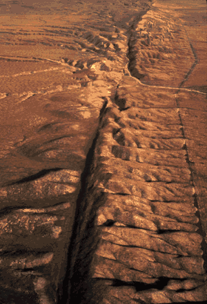
The San Andreas fault runs through south-central California and veers westward and out into the ocean just north of San Francisco. The San Andreas is a major right lateral strike-slip fault. This means that the western side of it is moving north, while the eastern side is moving south. Look at this air photo of the San Andreas in Southern California. Note the river that is offset.
Earthquakes occur constantly. For a list of recent earthquakes in California, check out this USGS web site for quakes in California. Have you felt any of the recent quakes? Probably not, as most have less than a magnitude of 3. What do we mean when we talk about earthquake magnitude? Magnitude is traditionally measured on the Richter scale. The Richter scale is a logarithmic scale which describes the amount of energy released by a quake with a number. Each whole number increase in the Richter scale (say, from a 6.0 to a 7.0) reflects a 10-fold increase in the amount of energy released. That is to say, that a magnitude 7 quake is much, much worse than a magnitude 6. Another measurement of earthquakes is the Mercalli intensity scale, which rates a quake on a roman-numeral scale from I to XII. The Mercalli scale is based on the damage an area received. Therefore, the Loma Prieta quake, which rated a 7.1 on the Richter scale, might have received a IX or X on the Mercalli scale near its epicenter, but it received a IV where I lived in Modesto, some 200 miles from the epicenter. You may want to do some research to learn more about the characteristics of damages and the frequency expected from earthquakes on both intensity scales.