3.8: Topographic Maps Lab Assignment
- Page ID
- 5475

Overview
This Lab Assignment is to be mailed to your Instructor at the contact address recorded in the Syllabus. Make sure that you use additional postage if needed. There is no online assessment for the Topographic Maps Lab.
Note
This lab is in color. Therefore, if you print it out in black and white please refer back to the electronic copy to avoid confusion.
Complete the entire assignment and mail to your instructor postmarked by the assignment deadline. You should make an extra copy to practice on and mail in a clean and neat version for grading. Make sure to include your name on every page and staple all of the pages together.
Please take advantage of all of the resources available to you. Be sure to read the corresponding lecture which contains directions to work out the solutions to the problems below. You should also review the instructional videos located in the unit content area within the course for additional assistance. Finally, check the Topographic Map Unit Discussion forum and the tutor talk area for additional resources and hints.
Topographic Maps Lab
For all of the following figures, assume North is up.
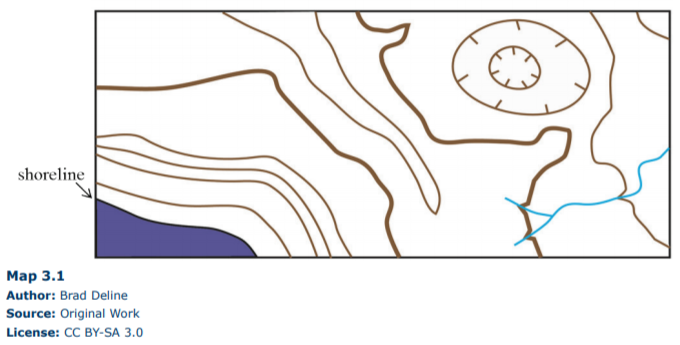
1. (10 pts) The following topographic map (Map 3.1) is from a coastal area and features an interesting geological hazard in addition to the Ocean. Using a contour interval of 40 meters, label the elevation of every contour line on the map below. (Note: elevation is the meters above sea level, which makes sea level = _____m).
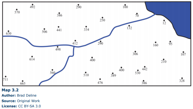
2. (10 pts) Imagine you are a geologist for the United States Geological Survey. You are tasked with creating your own coastal Topographic map, so you hike around the area with a GPS receiver (Global Positioning System) and every so often you record your position along with the elevation in meters at that point, which results in the following map (Map 3.2). Complete Map 3.2 by adding in the contour lines using a contour interval of 100 meters. Draw the contour lines so that they are continuous (do not die off), and either continue off the map or form an enclosed circle (look at the topographic map in the problem 1 for an example). More often than not, your contour lines will fall between the GPS points on your map, so do your best to determine the contour line positions.
For questions 3-7, refer to Map 3.3. The following topographic map shows an interesting and informative geological feature called a drumlin, which is a pile of sediment left behind by a retreating glacier.
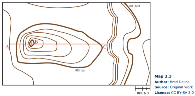
3. (2 pts) What is the contour interval on Map 3.3?
4. (2 pts) What is the regional relief on Map 3.3?
5. (5 pts) Using the contour lines on Map 3.3, which area along the red line is steeper A to B or B to C? Explain how you came to this conclusion.
6. (5 pts) What is the gradient from A to B and B to C on Map 3.3? Show your work.
7. (2 pts) Drumlins can be used to determine the direction of movement in the glacier with the glacier moving toward the shallower side of the structure. Using your previous answers for Map 3.3, what direction was the glacier traveling?
8. (20 pts) Construct a topographic profile from A to A’ on the graph paper below.
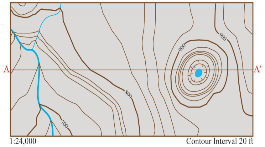
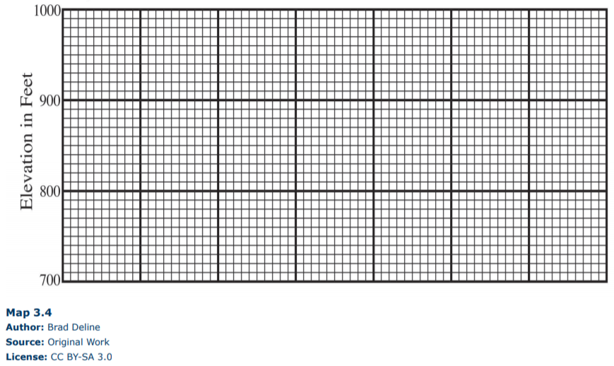
9. (5 pts) Based on the scale you choose for the topography (vertical axis) in question 8, calculate the amount of vertical exaggeration on the topographic profile you constructed above. Show your work.
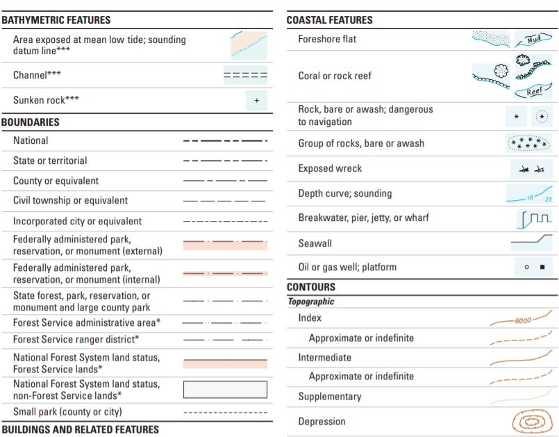
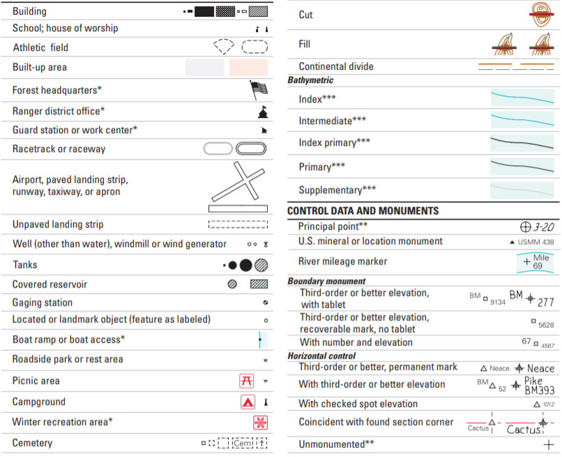
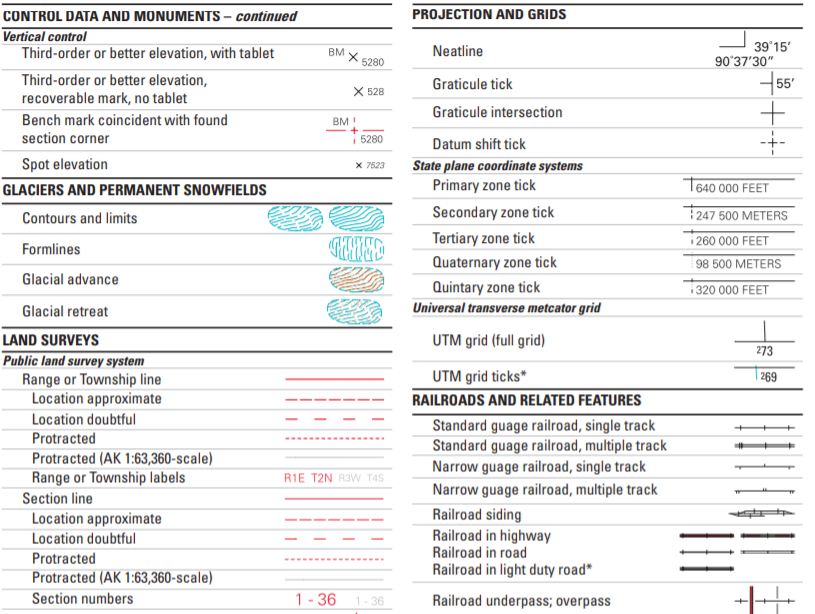
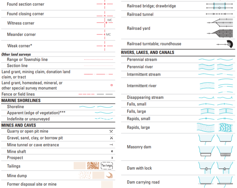
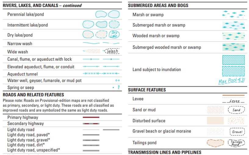
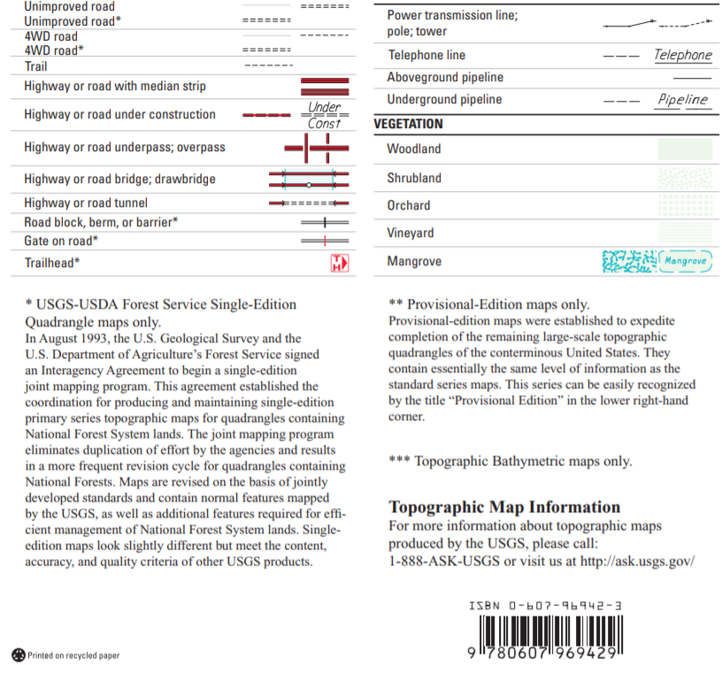
For this part of the lab, you will need to use Maps 3.5 and 3.6 (appearing at the end of this chapter). Following Maps 3.5 and 3.6 is a Map Key that you can use to identify the various symbols found on topographic maps. Also, note that the maps are in color and the colors have significance in terms of the symbols.
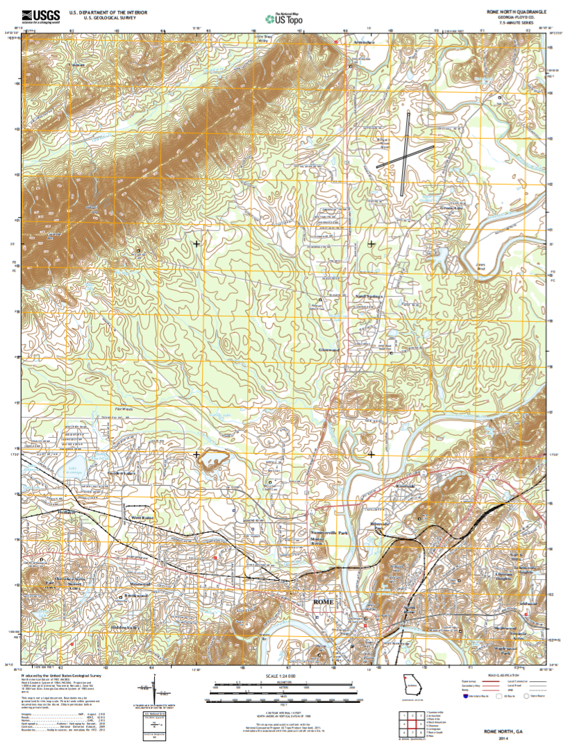
Questions 10-18: Rome North Quadrangle (27 pts)
10. (2 pts) What is the ratio scale of this map?
11. (2 pts) Explain in a sentence how this type of scale works.
12. (2 pts) What is the latitude on the north edge of the map?
13. (2 pts) What is the longitude on the east edge of the map?
14. (6 pts) Find Big Dry Creek, which is north of Rome. What direction does that river flow? Explain two reasons why you came to this conclusion.
15. (2 pts) Examine the large Ridge in the northwestern portion of the map. What is the tallest point in this ridge? How tall is it?
16. (2 pts) How much higher is that point from Lake Conasauga?
17. (5 pts) What is the gradient between Lake Conasauga and the tallest point in the ridge? Show your work (Hint: zooming out will let you see both features on the map at the same time and may make it easier to measure).
18. (4 pts) How would the gradient change if you measured from Swan Lake to the tallest point in the ridge rather than Lake Conasauga? Explain why.
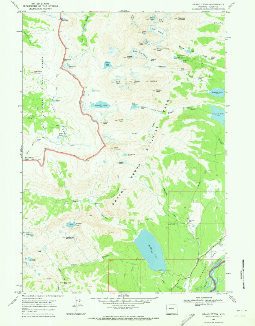
Questions 19-22: Grand Tetons (12 pts)
19. (3 pts) Explain why this map is referred to as a 7.5-minute map?
20. (3 pts) What is the relief on this map?
21. (2 pts) Does Taggert Creek flow into Taggert Lake or Lake Taminah? What direction does the creek flow?
22. (4 pts) Garnet Canyon (a little to the west of the word Garnet) is a common camping location for hikers and mountain climbers at the Grand Teton’s National Park. Examine the topography surrounding Garnet Canyon and the Middle Teton. What would be the easiest and safest route from Garnet Canyon to the top of the Middle Teton? Explain why. (Drawing a simple map will help).
For maps with higher quality, use the link below and go to page 64-65: