
4.3: Lab Exercise (Part A)
- Page ID
- 5479

Overview
This lab will use two different ways to input your answers. Most of the questions will be multiple choice and submitted online as you have in previous labs. Other questions will give you a blank box to input your answer as text. Your professor will manually grade this text, such that the format is not as important as your answer. This format allows you the opportunity to show your work using simple symbols and allows the instructor to better see your thought process. Also, note that for many of these questions there is not a single correct answer and seeing your thought process and understanding the material is more important than your answer. Therefore, it is important to show your work.
In addition, several of the exercises follow the use of Google Earth. For each question (or set of questions), paste the location that is given into the “search” box. Examine each location at multiple eye altitudes and differing amounts of tilt. For any measurements use the ruler tool, this can be accessed by clicking on the ruler icon above the image.
Part A – Plate Motion and Evidence
As was mentioned above one of the most striking things about the geography of the continents today is how they appear to fit together like puzzle pieces. The reason for this is clear: they once were connected in the past and have since separated shifting into their current positions. Open Google Earth and zoom out to an eye altitude of ~8000 miles. Examine the coastlines of eastern South America and Western Africa and notice how well they match in shape.
There are scientifically important rock deposits in southern Brazil, South America and Angola, Africa that show the northernmost glacial deposits on the ancient continent of Pangaea, which indicates these two areas were once connected. Based on the shape of the two coastlines, give the present-day latitude and longitude of two sites along the coast of these countries that used to be connected when the two continents were joined as a part of Pangaea (note: there are multiple correct answers):
1. Brazil (Latitude and Longitude)
2. Angola (Latitude and Longitude)
3. Measure in centimeters the distance (Map Length) between the two points you recorded in the previous question. Given that this portion of Pangaea broke apart 200,000,000 years ago, calculate how fast South America and Africa are separating in cm/year? (Hint: \(Speed= \frac{Distance}{Time}\))
4. When will the next supercontinent form? Examine the Western Coast of South America, the Eastern Coast of Asia, and the Pacific Ocean. If South America and Africa are separating and the Atlantic Ocean is growing, then the opposite must be occurring on the other side of the earth (the Americas are getting closer to Asia and the Pacific Ocean is shrinking). How far apart are North America and Mainland Asia in cm? (measure the distance across the Pacific at 40 degrees north latitude- basically measure between Northern California and North Korea)? Take that distance and divide it by the speed you calculated in question 3 to estimate when the next supercontinent will form. Show your work!
Use Figures 4.1 and 4.2 to answer questions 5-7.
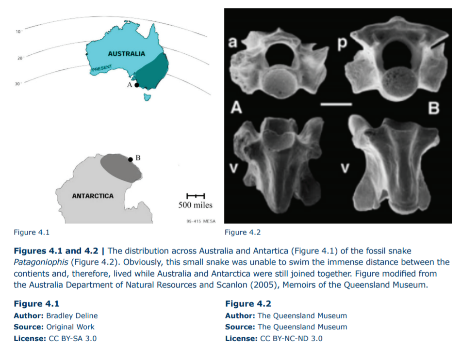
5. How far have the snake fossils moved apart since they were originally deposited?
a. 1250 miles b. 1700 miles c. 2150 miles d. 2700 miles
6. Given that this portion of the Australian plate moves at a speed of 2.2 inches per year, how old are the snake fossils?
a. 310 million years old b. 217 million years old c. 98 million years old d. 62 million years old e. 34 million years old
7. There are fossils such as Glossopteris and Lystrosaurus that are found in rocks in South America and Africa that indicate they were part of Pangaea approximately 200 million years ago. These same fossils can be found in Australia, which indicates it, along with Antarctica, was also part of Pangaea at that time. Based on your answer to question 6 which of the following statements about the break-up of Pangaea is TRUE?
a. Australia and Antarctica separated before the break-up of Pangaea.
b. Australia and Antarctica separated during the break-up of Pangaea.
c. Australia and Antarctica separated after the break-up of Pangaea.