
12.6: Geologic Maps and Cross-Sections
- Page ID
- 5678

Overview
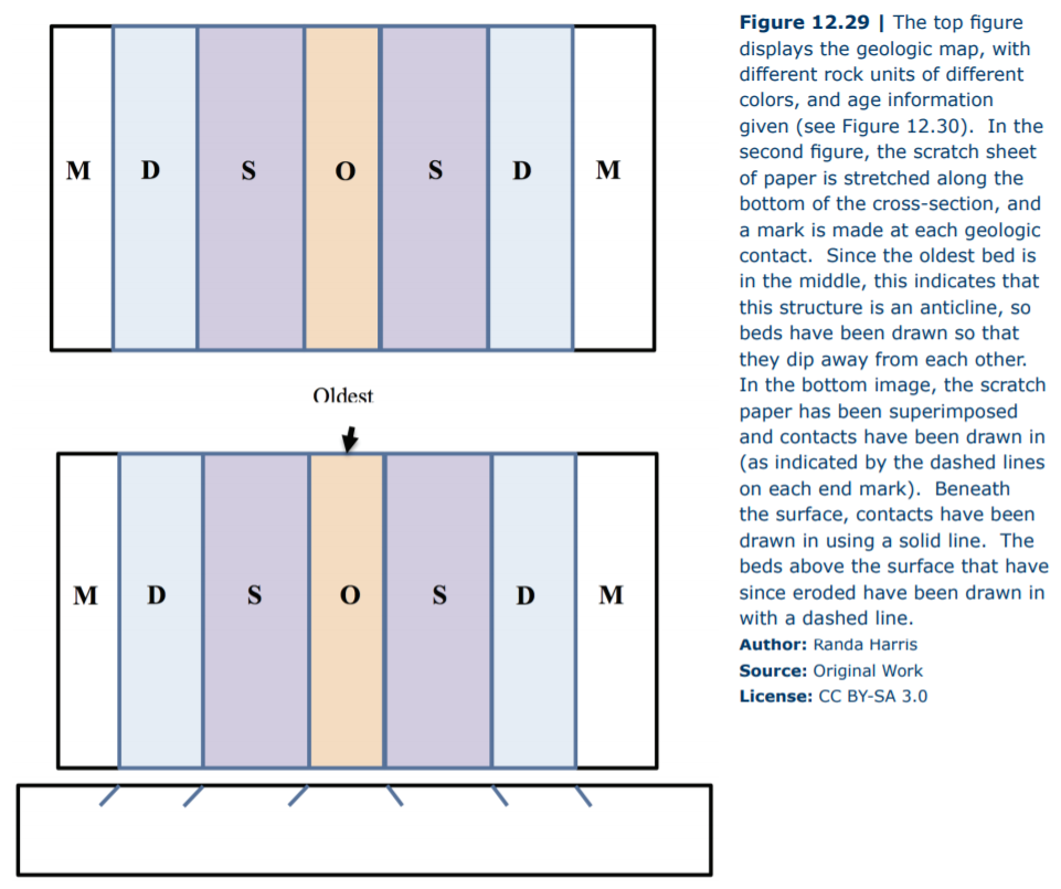
A geologic map uses lines, symbols, and colors, to include information about the nature and distribution of rock units within an area. It includes a base map, over which information about geologic contacts and strikes and dips are included. Geologists make these maps by careful field observations at numerous outcrops (exposed rocks at the Earth’s surface) throughout the mapping area. At each outcrop, geologists record information such as rock type, strike and dip of the rock layers, and relative age data. Geologic maps take practice to understand, as three-dimensional features (such as folds) are displayed on a two-dimensional surface. Remember that a geologic map will be seen in map view, as we learned about earlier with the block diagrams. Geologists use information about rocks that are exposed to visualize the unseen rocks beneath the surface, enabling them to complete the cross-sectional views we observed in the blocks. You will examine a geologic map for an area in Georgia and construct a geologic cross-section. A geologic cross-section shows geologic features from the side view. They are similar to the topographic profiles that you have already created, but include additional information about the rocks present. In order to construct a geologic cross-section, obey the following steps:
- Observe the geologic map given. Pay close attention to any strike and dip symbols, geologic contacts, and ages of the rock types.
- Take a scratch sheet of paper. Line it up along the line provided across the cross-section.
- At each geologic contact, make a mark on the scratch paper. Position the marks in the direction you believe the rocks are dipping (To determine this, use strike and dip symbols. If they are not provided, use the Rule of V’s or the ages given to help determine the geologic structure).
- Transfer the marks from your paper to a provided diagram.
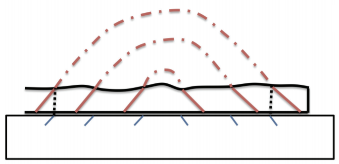
- Sketch in the structure, paying careful attention to dip angles (if provided). Structures may be drawn in with a dotted line above the Earth’s surface to indicate rocks that were formerly present but that have since been eroded.
There are some helpful hints to remember when constructing a cross-section:
- Anticlines – these folds have the oldest beds in the middle, with beds dipping away from the axis. Plunging anticlines plunge towards the closed end of the V.
- Synclines – these folds have the youngest beds in the middle, with beds dipping towards the axis. Plunging synclines plunge towards the open end of the V.
- As streams intersect dipping beds of rock, they will cut V shapes in the direction of dip.
Figure 12.29 provides an example of a simple geologic cross-section, based off ages of the rock units.
| Guide To Rock Ages | ||
| Age of Rocks | Geologic Age Symbol | Geologic Time Period |
|
From Youngest l l l l l l l l l l l l l l l l l l l l l V To Oldest |
Q | Quaternary |
| T | Tertiary | |
| K | Cretaceous | |
| J | Jurassic | |
| Tr | Triassic | |
| P | Permian | |
| lP | Pennsylvanian | |
| M | Mississippian | |
| D | Devonian | |
| S | Silurian | |
| O | Ordovician | |
| -C | Cambrian | |
| p-C | PreCambrian | |
| Guide To Common Map Symbols | |
| Map Symbol | Explanation |
 |
Strike & Dip |
 |
Vertical Strata |
 |
Horizontal Strata |
 |
Anticline Axis |
 |
Syncline Axis |
 |
Plunging Anticline Axis |
 |
Plunging Syncline Axis |
 |
Strike-slip Fault |